Thursday weather planner: Rain, storms to help move out smoke but could impact weekend events

Updated: 8:14 AM EDT Jun 29, 2023
BLACK PEOPLE IN AMERICA. I I’M BIASED, BUT I FELT LIKE CINCINNATI. THERE WERE SEVERAL THOSE MURALS THAT WENT UP A COUPLE OF YEARS AGO, AND I THINK OURS WAS JUST ONE OF THE MOST UNIQUE AND SO BEAUTIFUL. SO GREAT TO SEE THEM OUT THERE, MAKING SURE THAT THAT GETS PRESERVED. RANDI, IF THEY’RE GOING TO BE OUT. WATER BREAKS, TAKING TIME TO GET INSIDE, KIND OF GETTING THAT FRESH AIR BECAUSE WE’RE STILL DEALING WITH THAT SMOKE AND WE WILL TODAY. YESTERDAY WAS LIKELY THE WORST OF IT. TODAY WE SHOULD SEE SOME IMPROVEMENTS. BUT EVEN THIS MORNING, THE AIR QUALITY IS STILL REGISTERING UNHEALTHY LEVELS. COUPLE OF THINGS ARE GOING TO HELP US OUT HERE OVER THE NEXT COUPLE OF DAYS. THE WINDS ARE GOING TO SHIFT OUT OF THE SOUTH. THAT IS PULLING IN A DIFFERENT AIR MASS. UNFORTUNATELY, THAT IS ALSO A VERY WARM AND STEAMY AIR MASS THAT WILL HELP TO TRIGGER ROUNDS OF THUNDERSTORMS FOR US, REALLY STARTING AS EARLY AS THIS EVENING. AND LASTING OFF AND ON ALL THE WAY INTO MONDAY. SO WE GO FROM SMOKE TO STORMS OVER THE NEXT COUPLE OF DAYS. TODAY, OF COURSE, THE AIR QUALITY ALERT CONTINUE AS THE BIGGEST ISSUE WILL BE THE SMOKE AND THE FOG. HOWEVER, IT WILL BE IMPROVED EVENING, ESPECIALLY INTO THE EVENING HOURS AS OUR NEXT WILL H SOME OF THAT SMOKE. SO BACK UP AGAIN. AND THAT’S GOING TO HAPPEN OFTEN ON FRIDAY, SATURDAY, AND RIGHT NOW IT’S STILL TOO EARLY TO TELL WHETHER THAT MEANS A STORM IS GOING TO BE IN FIVE, 6 P.M. TOMORROW OR NOT. RIGHT. I THINK WE’RE DEFINITELY GOING TO SEE AT LEAST AROUND I THINK IN THE EARLY AFTERNOON AND WE COULD SEE DEPENDING ON IF THIS ONE DIES OUT, THE POTENTIAL FOR SOME OF OUR WESTERN COMMUNITIES TO MAYBE SEE A LITTLE BIT OF RAIN TODAY. SO THIS LINE HOLDING TOGETHER AS IT MAKES ITS WAY THROUGH CENTRAL PORTIONS OF ILLINOIS. BUT THIS IS GOING TO BE WHAT WE’RE GOING TO BE DEALING WITH OVER THE NEXT COUPLE OF DAYS. CLUSTERS OF STORMS THAT START TO OUT WEST AND HOLD TOGETHER AND RUMBLE THROUGH OUR AREA OFF AND ON RIGHT. WE HAVE THE SMOKY SKIES THOUGH CVG IS REPORTING CLEAR SKIES. THE VISIBILITY IS ONLY TWO MILES. THIS AT THE MOMENT. AND THE TEMPERATURE RIGHT NOW, 67 DEGREES. SO THE OUTLOOK FOR TODAY, IT LOOKS VERY SIMILAR TO YESTERDAY. RIGHT. EXPECT THE SMOKY HAZE, TEMPERATURES LIKELY TO MAKE IT TO THE MID OR EVEN UPPER EIGHTIES AS WE GET INTO THE AFTERNOON. BUT THEN FOR FRIDAY AND SATURDAY, YOUR HEAT, IT’S GOING TO FEEL LIKE THE MID NINETIES DUE TO THE HIGH HUMIDITY. THE RAIN THREAT, SCATTERED STORMS ARE LIKELY AND SOME OF THEM COULD BE STRONG. I WANT TO SHOW YOU THE SEVERE WEATHER THREAT FOR TOMORROW. YOU’LL NOTICE WHERE THOSE STORMS ARE KIND OF IGNITING OFF TOWARD AREAS LIKE MISSOURI AND ILLINOIS. AND THEN THEY’LL DRIFT IN OUR DIRECTION. SO TOMORROW WE DO HAVE THE POTENTIAL THAT SOME OF THOSE STORMS COULD BE ON THE STRONGER SIDE WITH WIND OR HAIL BEING YOUR MAIN CONCERN. AND FAST FORWARD INTO SATURDAY, SAME THING. SO WE DO HAVE A SLIGHT RISK FOR STRONGER STORMS WITH OUR WEEKEND. HERE’S THE SEVEN DAY TODAY, 88 DEGREES WITH THE SMOKE AS THE MAIN CONCERN STARTING AS EARLY AS TONIGHT. OUR RAIN CHANCES START TO GO UP. SO WE’LL BE WATCHING THOSE CLUSTERS OF STORMS THAT DEVELOP TO THE WEST AND SLIDE EAST. THAT WILL BRING US OFTEN ON ROUNDS OF RAIN FRIDAY, SUNDAY, I THINK FEWER OF THEM MONDAY. AND AS OF RIGHT NOW, THE 4TH OF JULY ON TUESDAY IS LOOKING DRY, NOT TOO HUMID WITH TEMPERATURES IN THE MID EIGHTIES. SO SHOULD BE DECENT FO
Thursday weather planner: Rain, storms to help move out smoke but could impact weekend events
Updated: 8:14 AM EDT Jun 29, 2023
An Air Quality Alert is in effect for Greater Cincinnati through Thursday. The AQI is the highest it's been since at least 2000, when the EPA began keeping track.Swifties and sports fans, keep an eye on the weekend forecast! Rain and storms will likely impact an event at some point this weekend.Thursday starts locked in with the smokey haze. A shift in the winds and some approaching rain will help clear the smoke over the next 24 hours.Most towns stay mainly dry on Thursday (we may see a shower in Indiana mid-to-late morning), with high temperatures jumping and humidity slowly increasing.Highs warm to the middle and upper 80s. Thursday night likely brings in our first cluster of storms.Highs Friday top out to close to 90 degrees and there will be afternoon/evening thunderstorms in the area, including downtown. Whether dressing for your favorite Taylor Era or going to Great American Ball Park, prepare for heat and potential lightning.It's important to remember that, at any point this weekend, these storms could be strong.Scattered thunderstorms redevelop Saturday afternoon. Highs climb near 90 as humidity climbs yet again. It rains when Taylor's here and rains when Taylor's gone.Sunday brings much of the same with afternoon storms that could become strong.
An Air Quality Alert is in effect for Greater Cincinnati through Thursday. The AQI is the highest it's been since at least 2000, when the EPA began keeping track.
This content is imported from Twitter.
You may be able to find the same content in another format, or you may be able to find more information, at their web site.
Swifties and sports fans, keep an eye on the weekend forecast! Rain and storms will likely impact an event at some point this weekend.
Thursday starts locked in with the smokey haze. A shift in the winds and some approaching rain will help clear the smoke over the next 24 hours.
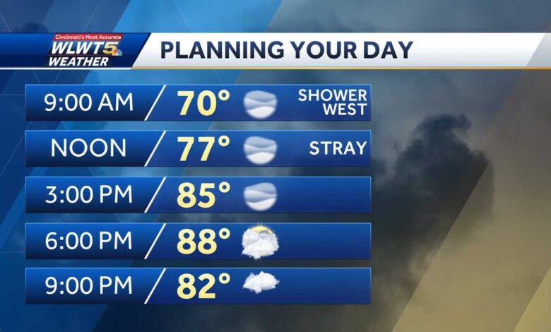
Most towns stay mainly dry on Thursday (we may see a shower in Indiana mid-to-late morning), with high temperatures jumping and humidity slowly increasing.
Highs warm to the middle and upper 80s. Thursday night likely brings in our first cluster of storms.
Highs Friday top out to close to 90 degrees and there will be afternoon/evening thunderstorms in the area, including downtown. Whether dressing for your favorite Taylor Era or going to Great American Ball Park, prepare for heat and potential lightning.
It's important to remember that, at any point this weekend, these storms could be strong.
Scattered thunderstorms redevelop Saturday afternoon. Highs climb near 90 as humidity climbs yet again. It rains when Taylor's here and rains when Taylor's gone.
Sunday brings much of the same with afternoon storms that could become strong.
Source link