Florida monitors a growing Tropical Storm Ian in Caribbean

Updated: 8:33 AM EDT Sep 25, 2022
alright with this west to alright with this west to facebook live update. Just wanted to give *** quick update here from the two o'clock intermediate advisory doesn't affect the cone, but it certainly does give us *** better idea as to what's going on out there in the tropics. Again, very active, very busy out there. We've got post tropical Fiona doing *** lot of destruction Southeast, Canada Gastone again over to the south and west of Lisbon and then her mean is gonna kind of hug the host coast there west africa, another little wave there in between the lesser Antilles. In africa, not gonna do much and then all eyes of course are going to be on IAN here as it continues to develop. I wanted to get *** little bit of *** close up shot here for you kind of give you the the latest look on it and you can see what's going on right there. It's uh starting to get that look that that turning and twisting, trying to get those storms there around the the entire corps, not just one side, which is what we were seeing earlier this morning water vapor channel here yesterday. We had of course *** lot of wind shear not seeing as much of that today as we did yesterday. So you still have that little uh high to the north right in there. There's *** little bit of *** low, it's kind of like right in here and one of the things that we're gonna have to watch is this, how soon does this begin to turn even more towards the west northwest and then the northwest as it moves off, generally speaking to the west. So that's again one of the things that we're gonna be watching, remember that Northwestern Caribbean folks. Uh It is Jacked. This is some high octane, deep warm water in the northwestern caribbean. So the farther west that this goes closer to Cancun on the western tip there of Havana, That would mean more added additional potential for this storm to try and develop. There's Ian, this is the two o'clock advisory. Now, moving west. Okay, moving west at 16 Windsor at 45 miles an hour, pressure is starting to come down as we uh as we go through and have gone through the last 24 hours. Let me show you the the tip of the cone. There big differences here, so to speak, in the advancement more towards the north, all of central florida is now in the cone. Believe it or not, Miami date is not because of that trend more towards the west here. Um bringing that track there just north of Tampa approaching her nando county and potentially Marion County while uh potentially shooting up towards Jacksonville. So again, you take *** look at the storm tracks, we get new models coming in here within the next hour. But the trend this morning has been more towards the west. Look at that between Cancun and Havana look at laser locked in. That's what's going on right there. Then we start to see that bend from the big bend, that's the H worf over towards the I. Four corridor. Uh Let me see if I can see uh Let me do it. Let me show it to you this way. So this is gonna this is gonna be uh let's see your models don't want to do that, let's do the animation. I wanna show you, Give me the animation. Just bear with me right there, there's *** look at the animation and and notice there's our storm incredibly good agreement. Now west of Havana potentially staying in the core of the warmest waters right there. Then by Wednesday you can start to see that turn Tampa west of Tampa I four is the right side of the envelope of the models and then *** good chunk of them, very close to Marion County and over towards the big bend there of the panhandle. So again, *** lot to watch here but again little bit of *** push back towards the west. Now one of the things I love to do is show you the cone but then superimposed all of the models. Very good agreement. Initially there one the one model there on the outside of the left side of it. But notice how for the most part the majority of the models on that center point and then off to the north and west, center point off towards the north and the west. We'll get some new model runs here between 2 33 30 and have those on air for you tonight at five and six. So that's the trend. That's the tendency, we're still in that front, right quadrant. But the point I've got to make here for everybody is that, you know, the farther west the center of the storm goes, the core of the strongest winds go farther to the west. And that's what we're hoping for as it becomes really game time by Tuesday, Wednesday and thursday of next week, models here all indicating *** major hurricane uh by as early as monday night. Uh And then as we go through Tuesday and Wednesday, you can see Cat three and Cat four potential storm, they're either going up the western side of the florida peninsula or or coming ashore. So *** lot of people have been asking me about charley and Frances charlie, is that blue line? And there's the cone. Now the IAN forecast again, just to the west of that, so very similar. And we're watching this cold front to the north of it as we go through the next couple of days, the longer the time it takes for this storm to make that turn to the north, the farther west, I believe it'll go um as it comes into the gulf of Mexico Gfs pretty far to the west, the european now, which was over south florida two runs ago is coming ashore very close to the Tampa Bay area and you can see the gfs there. Uh Oops, I didn't mean to do that. The G. F. S right there, Gfs slowing down west of Tampa and look at the Euro coming in south of Tampa. So that has been the trend folks as we've gone through the last couple of model runs and that's what we're gonna continue to watch. So I'm gonna wrap this up with this particular graphic. Uh the timing of IAN, the first arriving tropical storm force winds, Tuesday evening, south florida, Wednesday morning, central florida. Um and then Wednesday evening up to the north. If it continues to slow down, we adjust those values back. If it looks like it's going to speed up, then we'll make *** Tuesday morning in yada yada yada. One final note, One final note, the rainfall forecast on many of the models is predicting anywhere from *** half *** foot to potentially *** foot of rain across central florida. So we need to make sure that your folks are paying close attention to all of the different components and aspects. Um, I do want to show this particular graphic here real quick. Um, so this is the wave action. This is the wave action based on *** Cat three Cat for potential hurricane, you can see the red orange. Look at that. 40 to 45 ft wave action right there. You talk about the potential for storm surge. It's, it's, it's incredible. That's one of the things folks that we're gonna have to watch. Um as we, as we sit and babysit this thing in the timeline, one more time. I'm gonna end it on this. So today, you know, the trend has been more towards the west. That's good. We still want you to get those hurricane kids taken care of this weekend monday. You're putting up some some uh apply locks. If you have that storm shutters, you're, you're thinking about shutting them for for for Tuesday and then Wednesday we think the storm is gonna arrive. So The confidence today, we're still, there's still *** good divergence at the end. So it's still low. We think that that's gonna improve though by Sunday, Monday and Tuesday. Alright, game. Gotta answer the phone. Boss is calling. I have an update on Facebook live again tonight at eight
Authorities and residents in Florida were keeping a cautious eye on Tropical Storm Ian as it rumbled through the Caribbean on Sunday, expected to continue gaining strength and become a major hurricane in the coming days on a forecast track toward the state.Gov. Ron DeSantis declared a state of emergency for all of Florida the previous day, expanding an initial order that had covered two dozen counties. He urged residents to prepare for a storm that could lash large swaths of the state with heavy rains, high winds and rising seas.“We encourage all Floridians to make their preparations,” DeSantis said in a statement.President Joe Biden also declared an emergency, authorizing the Department of Homeland Security and the Federal Emergency Management Agency, or FEMA, to coordinate disaster relief and provide assistance to protect lives and property. The president postponed a scheduled Sept. 27 trip to Florida due to the storm.The National Hurricane Center said Ian was expected to strengthen before moving over western Cuba and toward the west coast of Florida and the Florida Panhandle by the middle of the week. The agency advised Floridians to have hurricane plans in place and monitor updates of the storm's evolving path.The center issued an updated advisory at 5 a.m. Sunday, which noted the tropical storm was forecast to begin “rapidly strengthening later today” with the “risk of significant wind and storm surge impacts increasing for western Cuba.”Ian was expected to become a hurricane Sunday and a major hurricane as soon as late Monday. The storm had top sustained winds of 50 mph (85 kph) on Sunday morning as it swirled about 345 miles (555 kilometers) southeast of Grand Cayman, in the Cayman Islands.A hurricane warning remained in effect for the island and hurricane watches were issued for western Cuba.John Cangialosi, a senior hurricane specialist at the Miami-based center, said it was not yet clear exactly where Ian will hit hardest. He said Floridians should begin preparations, including gathering supplies for potential power outages.“At this point really the right message for those living in Florida is that you have to watch forecasts and get ready and prepare yourself for potential impact from this tropical system,” he said.In Pinellas Park, near Tampa, people were waiting in line at a Home Depot when it opened at 6 a.m. Saturday, the Tampa Bay Times reported. Manager Wendy Macrini said the store had sold 600 cases of water by early afternoon and ran out of generators.People also were buying up plywood to shore up their windows: “Better to have it and not need it than to need it and not have it,” Matt Beaver, of Pinellas Park, told the Times.Elsewhere, powerful post-tropical cyclone Fiona crashed ashore Saturday in Nova Scotia in the Atlantic Canada region, washing houses into the sea, tearing off rooftops and knocking out power to more than 500,000 customers in two provinces.
Authorities and residents in Florida were keeping a cautious eye on Tropical Storm Ian as it rumbled through the Caribbean on Sunday, expected to continue gaining strength and become a major hurricane in the coming days on a forecast track toward the state.
Gov. Ron DeSantis declared a state of emergency for all of Florida the previous day, expanding an initial order that had covered two dozen counties. He urged residents to prepare for a storm that could lash large swaths of the state with heavy rains, high winds and rising seas.
“We encourage all Floridians to make their preparations,” DeSantis said in a statement.
President Joe Biden also declared an emergency, authorizing the Department of Homeland Security and the Federal Emergency Management Agency, or FEMA, to coordinate disaster relief and provide assistance to protect lives and property. The president postponed a scheduled Sept. 27 trip to Florida due to the storm.
The National Hurricane Center said Ian was expected to strengthen before moving over western Cuba and toward the west coast of Florida and the Florida Panhandle by the middle of the week. The agency advised Floridians to have hurricane plans in place and monitor updates of the storm's evolving path.
The center issued an updated advisory at 5 a.m. Sunday, which noted the tropical storm was forecast to begin “rapidly strengthening later today” with the “risk of significant wind and storm surge impacts increasing for western Cuba.”
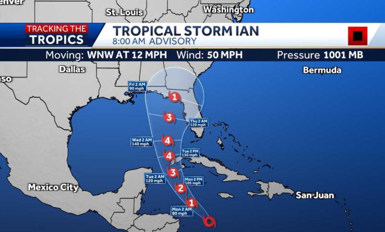
Ian was expected to become a hurricane Sunday and a major hurricane as soon as late Monday. The storm had top sustained winds of 50 mph (85 kph) on Sunday morning as it swirled about 345 miles (555 kilometers) southeast of Grand Cayman, in the Cayman Islands.
A hurricane warning remained in effect for the island and hurricane watches were issued for western Cuba.
John Cangialosi, a senior hurricane specialist at the Miami-based center, said it was not yet clear exactly where Ian will hit hardest. He said Floridians should begin preparations, including gathering supplies for potential power outages.
“At this point really the right message for those living in Florida is that you have to watch forecasts and get ready and prepare yourself for potential impact from this tropical system,” he said.
In Pinellas Park, near Tampa, people were waiting in line at a Home Depot when it opened at 6 a.m. Saturday, the Tampa Bay Times reported. Manager Wendy Macrini said the store had sold 600 cases of water by early afternoon and ran out of generators.
People also were buying up plywood to shore up their windows: “Better to have it and not need it than to need it and not have it,” Matt Beaver, of Pinellas Park, told the Times.
Elsewhere, powerful post-tropical cyclone Fiona crashed ashore Saturday in Nova Scotia in the Atlantic Canada region, washing houses into the sea, tearing off rooftops and knocking out power to more than 500,000 customers in two provinces.
Source link