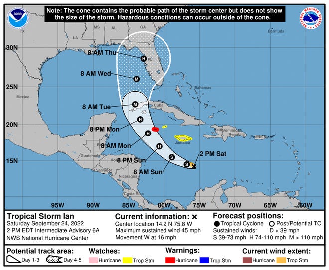
Forecasters expect Tropical Storm Ian to strengthen in the central Caribbean over the weekend, and the storm could become the first Atlantic hurricane to hit the mainland U.S. this hurricane season, with an anticipated arrival in Florida next week.
Ian was named a Tropical storm late Friday in the eastern Caribbean Sea and could become a major hurricane within days, forecasts say.
"Because of very warm waters and a forecast minimal amount of disruptive winds, there is the potential for the system to undergo rapid strengthening anytime from this weekend to midweek," said AccuWeather Lead Long-Range Meteorologist Paul Pastelok.
Here's what the National Hurricane Center expects in the next few days:
- The storm should pass southwest of Jamaica on Sunday.
- It is expected to become a hurricane around Sunday night.
- Ian's track will be near the Cayman Islands and Cuba on Monday.
- Early next week, the Florida Keys and South Florida may see heavy rains. Some flash and urban flooding are possible.
PREVIOUS REPORTS:Tropical Storm Ian forms in Caribbean, could hit Florida as a major hurricane

Florida braces for major hurricane
Florida Gov. Ron DeSantis has declared a state of emergency for 24 counties and warned on Twitter that while the storm's track is uncertain, "Floridians should remain vigilant and ensure their households are prepared for a potential impact."
There is potential for the storm's track to shift this weekend and into next week, according to AccuWeather forecasters.
"Pretty much everything is still on the table at this point, from the western Florida panhandle all the way down through the Florida peninsula for potential landfall," AccuWeather senior meteorologist Alyson Hoegg told USA TODAY.
Hoegg urged Florida residents to prepare for severe weather, even if they don't live exactly where predictions currently say the storm will make landfall: “We’re still expecting heavy rainfall all across the state regardless of the exact track the storm is ultimately going to take.”
John Cangialosi, a senior hurricane specialist with National Hurricane Center in Miami, shared a similar message: It's “too soon to say if it's going to be a southeast Florida problem or a central Florida problem or just the entire state,” he said.
“So at this point really the right message for those living in Florida is that you have to watch forecasts and get ready and prepare yourself for potential impact from this tropical system," Cangialosi said.
NASA has also decided to call off a Tuesday launch attempt due to impacts from the storm.
Ian path: Caribbean islands to be hit first
The Cayman Islands are currently under a hurricane watch, and Jamaica is under a tropical storm watch, according to the National Hurricane Center.
Jamaica is expected to see "progressively heavier downpours and increasing winds" Saturday and Sunday, AccuWeather said. Then, the storm is forecast to more directly hit the Cayman Islands and Cuba early in the week. .
HURRICANE FIONA:'Historic, extreme' Fiona wallops Atlantic Canada with hurricane-force winds, rain
The storm is likely to hit western Cuba as a Category 2 hurricane or stronger, AccuWeather forecasters said. The country may see 6 to 10 inches of rainfall with local maximums up to 14 inches, the National Hurricane Center forecast.
Heavy rain may cause flash flooding and mudslides in Jamaica and Cuba, according to the National Hurricane Center. As Ian hurtles through the western Caribbean islands, there is also a risk of widespread power outages and torrential rain, according to AccuWeather.
Contact News Now Reporter Christine Fernando at [email protected] or follow her on Twitter at @christinetfern.
Contributing: Emre Kelly, Florida Today; Associated Press


