Sunday is a Weather Impact Day as a strong round of rain and storms roll in from the northwest.LIVE RADAR // LATEST WEATHER ALERTA tornado watch has been issued for the Greater Cincinnati area until 11 p.m.Sunshine and humidity have built back up Sunday afternoon ahead of strong/severe storms that move in from the northwest moving southeast. Timing is still the same with areas of southeast Indiana seeing it around 5 to 7 p.m., then moving through greater Cincinnati around 6 to 8 p.m., before continuing to move east 8 to 10 p.m.While the rain early this morning could have helped decrease the severe threat slightly, you still need to be on guard. The best areas for potentially large hail or a strong tornado look to be along and west of I-75 tonight. As storms form that line, the threats would become primarily damaging winds or a spin-up tornado. A core or two of large hail is also possible. Storm threats will end around 10 p.m. or just after with a few scattered showers hanging around, breezy and somewhat humid overnight tonight.Stay with WLWT and check back frequently for forecast updates through the evening.
Sunday is a Weather Impact Day as a strong round of rain and storms roll in from the northwest.
LIVE RADAR // LATEST WEATHER ALERT
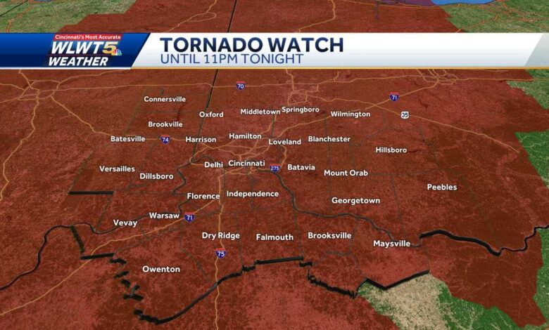
A tornado watch has been issued for the Greater Cincinnati area until 11 p.m.
This content is imported from Twitter.
You may be able to find the same content in another format, or you may be able to find more information, at their web site.
Sunshine and humidity have built back up Sunday afternoon ahead of strong/severe storms that move in from the northwest moving southeast. Timing is still the same with areas of southeast Indiana seeing it around 5 to 7 p.m., then moving through greater Cincinnati around 6 to 8 p.m., before continuing to move east 8 to 10 p.m.
While the rain early this morning could have helped decrease the severe threat slightly, you still need to be on guard.
The best areas for potentially large hail or a strong tornado look to be along and west of I-75 tonight. As storms form that line, the threats would become primarily damaging winds or a spin-up tornado.
A core or two of large hail is also possible. Storm threats will end around 10 p.m. or just after with a few scattered showers hanging around, breezy and somewhat humid overnight tonight.
Stay with WLWT and check back frequently for forecast updates through the evening.
Source link