Tropical Storm Cindy has gained some strength over the Atlantic Ocean.As of the advisory on Friday at 11 p.m., Cindy was 735 miles east of the Lesser Antilles and had maximum sustained winds of 50 mph. The storm was moving west-northwest at 15 mph."A west-northwestward to northwestward motion is expected over the next few days. On the forecast track, the system is expected to remain well east and northeast of the northern Leeward Islands through early next week," the National Hurricane Center said.Forecasters say gradual strengthening is expected in the next couple of days. However, beyond the next 48 hours, the deep-layer shear will combine with dry air, and likely weaken Cindy early next week. Tropical Storm Cindy forms behind Bret in an early and aggressive start to Atlantic hurricane seasonCindy is on Tropical Storm Bret's heels. Forecasters say it is the first time there are two storms in the tropical Atlantic in June since record keeping began in 1851. The historic event signals an early and aggressive start to the Atlantic hurricane season that began on June 1 and that usually peaks from mid-August to mid-October. Some forecasters blamed unusually high sea temperatures for the rare development.“The Atlantic is awfully warm this year,” said Kerry Emanuel, a meteorologist at the Massachusetts Institute of Technology, adding that it’s partly a result of global warming, natural variability and the ocean’s recovering from sulfate aerosols pollution that cooled it decades ago.Studies show that a warmer world is producing wetter and more intense hurricanes, with scientists still trying to figure out if climate change alters how many storms brew. Because of more early and pre-season storms, the National Hurricane Center has started issuing advisories earlier in the year, with experts recently discussing the idea of declaring the start of the hurricane season earlier.Emanuel noted that in the entire Atlantic Ocean, not just the tropical Atlantic, it’s not unusual to have storms in June. It has happened 34 times — including this year — since 1851, he said.Cindy is expected to remain a tropical storm as it heads northeast into open waters.Meanwhile, Bret brought winds, heavy rain and swells of up to 15 feet early Friday to islands in the eastern Caribbean that shut down to prepare for potential landslides and flooding. Officials in the French Caribbean island of Martinique said they were searching for four people who apparently were aboard a lifeboat after their catamaran sank during the storm.
Tropical Storm Cindy has gained some strength over the Atlantic Ocean.
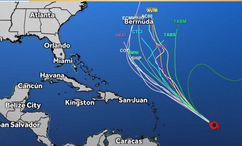
As of the advisory on Friday at 11 p.m., Cindy was 735 miles east of the Lesser Antilles and had maximum sustained winds of 50 mph. The storm was moving west-northwest at 15 mph.
"A west-northwestward to northwestward motion is expected over the next few days. On the forecast track, the system is expected to remain well east and northeast of the northern Leeward Islands through early next week," the National Hurricane Center said.
Forecasters say gradual strengthening is expected in the next couple of days. However, beyond the next 48 hours, the deep-layer shear will combine with dry air, and likely weaken Cindy early next week.
This content is imported from Twitter.
You may be able to find the same content in another format, or you may be able to find more information, at their web site.
This content is imported from Twitter.
You may be able to find the same content in another format, or you may be able to find more information, at their web site.
Tropical Storm Cindy forms behind Bret in an early and aggressive start to Atlantic hurricane season
Cindy is on Tropical Storm Bret's heels. Forecasters say it is the first time there are two storms in the tropical Atlantic in June since record keeping began in 1851.
The historic event signals an early and aggressive start to the Atlantic hurricane season that began on June 1 and that usually peaks from mid-August to mid-October. Some forecasters blamed unusually high sea temperatures for the rare development.
“The Atlantic is awfully warm this year,” said Kerry Emanuel, a meteorologist at the Massachusetts Institute of Technology, adding that it’s partly a result of global warming, natural variability and the ocean’s recovering from sulfate aerosols pollution that cooled it decades ago.
Studies show that a warmer world is producing wetter and more intense hurricanes, with scientists still trying to figure out if climate change alters how many storms brew. Because of more early and pre-season storms, the National Hurricane Center has started issuing advisories earlier in the year, with experts recently discussing the idea of declaring the start of the hurricane season earlier.
Emanuel noted that in the entire Atlantic Ocean, not just the tropical Atlantic, it’s not unusual to have storms in June. It has happened 34 times — including this year — since 1851, he said.
Cindy is expected to remain a tropical storm as it heads northeast into open waters.
Meanwhile, Bret brought winds, heavy rain and swells of up to 15 feet early Friday to islands in the eastern Caribbean that shut down to prepare for potential landslides and flooding. Officials in the French Caribbean island of Martinique said they were searching for four people who apparently were aboard a lifeboat after their catamaran sank during the storm.


