Sunday weather: Rain, gusty winds roll through as cooler temps arrive

Updated: 1:53 PM EDT Apr 16, 2023
BERNSTEIN WITH THE FORECAST. ADAM? YEAH, GOOD MORNING. VERY MILD AND VERY QUIET FOR THE TIME BEING THIS MORNING. AND THAT IS SOME GOOD NEWS AS WE ARE WAKING UP KIND OF STARTING YOUR DAY. IF YOU HAVE TO GET OUT TO BREAKFAST OR BRUNCH CHURCH LATER ON THIS MORNING, THINGS ARE LOOKING DECENT EARLY ON, BUT THEN MORE CHANGES COMING IN A LITTLE LATER. NOTHING TO SHOW YOU ON RADAR, JUST BESIDES SOME GROUND CLUTTER THAT WE SAW YESTERDAY MORNING AS WELL. WE HAD A LITTLE BIT OF AN ISOLATED SHOWER OUT IN RIPLEY COUNTY EARLIER AS WELL. BUT NOW WE’RE FOCUSING ON THIS SYSTEM OFF TO THE WEST THAT’S GOING TO BE MOVING INTO OUR REGION AS WE MOVE INTO LATER TODAY, BRINGING US SOME SHOWERS, STORMS IN GUSTY WINDS. NOW, THE SEVERE THREAT AS WE’LL TALK ABOUT, IS LOWER THAN WHAT WE SAW YESTERDAY AS WELL. SO THAT IS DEFINITELY SOME GOOD NEWS. BUT I WOULDN’T SAY WE’RE COMPLETELY OUT OF THE CLEAR 100%. BUT WE ARE WATCHING THAT TIMING BETWEEN ABOUT 11 AND 2 P.M., DEPENDING WHERE YOU ARE, AND WE’LL TALK ABOUT THAT AS WELL. BUT STRONGER STILL, WINDS GOING TO BE THE MAIN THREAT AS THE SHOWERS AND STORMS PUSH THROUGH. AND THEN AFTER THEY PUSH THROUGH, WE’RE GOING TO BE SEEING TEMPERATURES THAT ARE FALLING FOR THE REST OF THE DAY. SO AS FAR AS RAINFALL IMPACTS THIS MORNING, I CAN ALMOST GO LOW, BUT I WAY WITH MEDIUM FOR NOW, JUST BECAUSE OF A FEW ISOLATED SHOWERS THAT WE SAW. BUT BY NOONTIME, WE HAVE HIGH IMPACTS AND THEN BY TONIGHT AND INTO YOUR MONDAY, IT’S MORE JUST SCATTERED RAIN WHERE WE STILL SEE PLENTY OF BREAKS OUT THERE. BUT AS WE GO THROUGH THE REST OF THE DAY, WE’LL STILL SEE SOME OF THOSE SCATTERED SHOWERS. SO LET’S LOOK AT THIS ON FUTURE GUEST HERE, AS I MENTIONED THIS MORNING. NOT A WHOLE LOT HAPPENING OUT THERE AND THAT IS SOME GOOD NEWS FOR US. BUT AS WE GET INTO THEN LATER ON, AS WE APPROACH ABOUT 11 A.M., YOU START TO SEE THOSE STORMS APPROACHING PARTS OF SOUTHEAST INDIANA, EASTERN INDIANA AND THEN IT STARTS TO MOVE INTO OUR PARTS OF OUR TRI STATE AREA INTO PARTS OF CINCINNATI AND NORTHERN KENTUCKY, AND THEN CONTINUING TO BLOW THROUGH TO THE EAST. NOW, THIS MAIN FRONT OF THE COLD FRONT, THE LINE OF STORMS, THAT’S WHERE WE COULD SEE ANY THREAT FOR THE STRONG WINDS. WE’LL STILL SEE GUSTY WINDS EVEN AFTER THIS PAST AS WELL. WE COULD STILL SEE GUSTS 25, 30 PLUS MILES AN HOUR. BUT IF WE’RE GOING TO SEE ANYTHING SEVERE, IT’LL BE WITH THAT MAIN FRONT OF THE LINE. AND THEN AS WE GO THROUGH THE REST OF THE AFTERNOON INTO THE EVENING, IT’S JUST GENERAL SCATTERED SHOWERS, MAYBE A FEW RUMBLES OF THUNDER. BUT OVERALL, THAT’S GOING TO BE THEN CONTINUING INTO MONDAY MORNING. NOW, I TALKED ABOUT THAT SEVERE THREAT EARLIER, AND THIS IS ANOTHER LOOK AT IT, THAT MARGINAL RISK JUST OFF TO OUR EAST EARLIER YESTERDAY, IT WAS MORE TOWARDS CINCINNATI, INTO AREAS OF NORTHERN KENTUCKY. SO THAT IS SOME PROMISING NEWS FOR US. BUT AGAIN, BEING RIGHT ON THE LINE OF THAT AND KNOWING HOW THE STORMS HAVE BEEN HANDLED HERE IN THE PAST FEW WEEKS, THERE’S STILL GOING TO BE WE WATCHING THAT THREAT EITHER WAY. 64 RIGHT NOW IN LOVELAND, 60 IN CINCINNATI, 60 IN HILLSBORO AND BATESVILLE AS WELL IN INDIANA, 62 UP IN MASON. AS WE GO THROUGH THIS MORNING, I MENTIONED THOSE TEMPERATURES RISING JUST SLIGHTLY MORE BACK INTO THE MID TO UPPER SIXTIES OF ABOUT 1112. BUT ONCE THAT FRONT MOVES THROUGH THE REST OF THE DAY, TEMPERATURES ARE GOING TO BE DROPPING ALL DAY LONG THROUGH THE FIFTIES INTO THE FORTIES AND EVENTUALLY LATE TONIGHT INTO YOUR MONDAY MORNING, WE GET TEMPERATURES THAT ARE DOWNRIGHT NEAR 40 DEGREES. SOME AREAS POSSIBLY EVEN INTO THE UPPER THIRTIES. AND THEN WE’RE DEALING WITH SCATTERED SHOWERS. THE REST OF YOUR MONDAY WITH TEMPERATURES THAT ARE STAYING IN THE LOWER FIFTIES. THE GOOD NEWS IS AS WE HEAD TOWARDS THE MIDDLE OF THE WEEK, THOSE TEMPERATURES STARTING TO REBOUND A LITTLE BIT MORE WITH PLENTY OF SUNSHINE RETURNING TO THE FORECAST UNTIL ANOTHER SYSTEM IS LOOKING TO APPROACH OUR AREA BY THE END OF THE WORK AND SCHOOL WEEK. SO A LOT T
Sunday weather: Rain, gusty winds roll through as cooler temps arrive
Updated: 1:53 PM EDT Apr 16, 2023
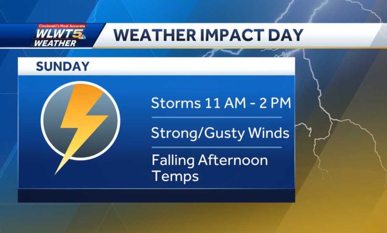
Changes are ahead this week with gusty storms today and cooler temperatures to come.We have started this Sunday on a mild and quiet note, but changes quickly move in by the afternoon. Beginning around 11 a.m. in parts of Indiana and moving quickly to the east, we'll see a cold front bring in showers, storms, and gusty winds across our region. It should arrive at the metro closer to Noon and then east by 2 p.m. Fortunately, our severe threat is lowering, but we aren't in the clear quite yet as strong winds will be the main concern.See the full forecast in the video player above.After the cold front moves through our region, temperatures will begin to drop from the 60s just before noon, to the mid-50s by the evening, and lower-40s overnight. Scattered showers will hang around overnight and into Monday where highs only top out in the mid-50s.Sunshine will return by the middle of the week with temperatures slowly warming up once again!
Changes are ahead this week with gusty storms today and cooler temperatures to come.
We have started this Sunday on a mild and quiet note, but changes quickly move in by the afternoon. Beginning around 11 a.m. in parts of Indiana and moving quickly to the east, we'll see a cold front bring in showers, storms, and gusty winds across our region. It should arrive at the metro closer to Noon and then east by 2 p.m.
Fortunately, our severe threat is lowering, but we aren't in the clear quite yet as strong winds will be the main concern.
See the full forecast in the video player above.
After the cold front moves through our region, temperatures will begin to drop from the 60s just before noon, to the mid-50s by the evening, and lower-40s overnight. Scattered showers will hang around overnight and into Monday where highs only top out in the mid-50s.
Sunshine will return by the middle of the week with temperatures slowly warming up once again!
Source link