START THE FIRE. WE ARE KEEPING A CLOSE EYEN O HURRICANE SAM. HERE’S SAM OUT HERE IN THE ATLANTIC. SO IT’S FAR AWAY FROM US. IT IS NOT A HURRICANE THAT IS BEARING DOWN ON US. IN FACT. HERE’S A LOOK AT HOWAR F AWAY IT ACTUALLY IS. SO THERE’S NEW ORLEANS AND THERE IS SAM. HERE’S A LOOK AT THE CONE SUSTAINED WINDS OF 75 MILESN A HOUR. IT DID OFFICIALLY BECOME A HURRICANE AS OF THE FOUR CLOCK ADVISORY FROM THE NATIONAL HURRICANE CENTER. IT IS MOVING WEST AT 15 MILES AN URHO AND IT’S UNDERGOING RAPID INTENSIFICATION. SO IT IS EXPECTED TO BECOME A CA TEGORY 3 HURRICANE A MAJOR HURRICANE BY THE WEEKEND AND EVEN SATURDAY NIGHT INTO SUNDAY MORNING A MAJOR CATEGORY 4 HURRICANE. THIS IS HEADING OUT TO THE WEST THESE ARE WHERE MODELS SWHO IT GOING AND THE GOOD NEWS IS RIGHT NOW IT SHOWS IT TURNING NTHOR ETH LESSER ANTILLES AND PERHAPS CONTINUING TO GO NORTH. SO THAT’S THE GDOO NEWS. THERE. IITS RIGHT NOW. THIS IS THE GLOBAL FORECAST MODEL SAME STORY HERE MOVING WEST BUT THEN STARTING TO TURN NORTH AND PERHAPS MOVING UP TOWARDS THE NORTHEAST AND TOWARDS NOVA SCOTIA. SO RIGHT NOW NOT AN ISSUE FOR US. WE’RE GONNA KEEP THE CLOSE EYE ON IT. THERE’S A LOT GOING ON IN THE TROPSIC THOUGH. WE ALSO HAVE THIS YOU HAVE DEVELOPMENT RIGHT HERE 40% CHANCE OF DEVELOPMENT SAME FOR THAT ONE UP THERE IN THE NORTHERN ATLANTIC, SO THE NEXT TWO NAMES TTHA WE COULD GET TO TERESA AND VICTOR NOTICE THAT WE’VE ALMOST ALREADY GONE THROUGH THE ENTIRE LIST THE NAMES AND THEN WE’D HAVE TO MOVE ON TO OUR ADDITIONAL LISTS OUR EXTRA LIST. MEANWHILE HEREN I SOUTHEAST LOUISIANA BEAUTIFUL MORNING 50S AND 60S ACROSS THE BOARD. SOT I IS NICE AND COOL OUTSIDE DEW POINTS IN THE 50S AS WELL. WHICH MEANS IT’S NOT HUMID. IT IS COMFORTABLE. WE WILL STAY IN THE 50S AND IT WILL SAY NICE AND PLEASANT THROUGHOUT THE DAY TODAY. SO A FORECAST INTO SRE A LITTLE BIT BREEZY OUT THERE FOR SOME OF YOU PARTICULARLY BY LAKE BUT TODAY HIGHS UPPER 70S TO LOW 80S. SIMIRLA TO WHAT? WE SAW YESTERDAY SUNNY SKIES LOW HUMIDITY AND AS WE HEAD INTO THE AFTERNOON COMFORTABLY WARM WITH THAT LOWER HUMIDITY. THEN OVERNIGHT TONIGHT BACK DOWN INTO THE 50S AND0S 6 ANOTHER VERYIM SILAR NIGHT TO WHAT WE HAVE SEEN AND THEN FOR THE WEEKEND WE DO START TO WARM UP A LITTLE BIT WE GET INTO THE MIDDLE 80S HUMIDITY WILL STILL STAY LOW. SO IT WILL BE NICE THROUGH THE WEEKEND. IT’S BY THE TUESDAY TIME FRAME WHERE I START STOEE HUMIDITY RETURNED TO THE FORECAST SO I’VE ADDED SOME LOWER-END RAIN CHANCES TEMPERATURES IN THE UPPER 80S AND MAYBE A BIT MORE HUMIDND A MUGGY OUT THERE, BUT THAT’S A FAR ENOUGH AWAY THAT WE CAN AT LEA ESTNJOY THIS UPCOMING WEEKEND.
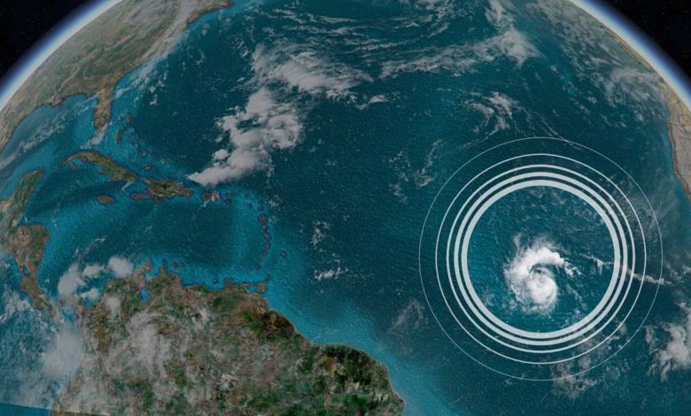
Hurricane Sam has formed and is intensifying over the Atlantic
Earlier a tropical storm, Sam has strengthened into a hurricane and is expected to continue intensifying, the National Hurricane Center said Friday.The storm is the seventh hurricane of the 2021 Atlantic season, with winds of 75 mph and even higher gusts, according to an NHC update Friday morning. Sam is forecast to become a major hurricane — Category 3 or higher — by Saturday afternoon.Sam started the day Thursday with winds of 35 mph and ended the day at 70 mph, signifying a rapid intensification, which occurs when a tropical cyclone strengthens by at least 35 mph in 24 hours.Moving to the west at 15 mph, Sam is approximately 1,470 miles east-southeast of the northern Leeward Islands, churning in open seas. Impacts from the storm, however, may be felt next week.Over the next five days, Sam will move toward the Leeward Islands and turn slightly northward as it approaches the islands."What is not clear at this point is what impacts it will have on land," CNN meteorologist Dave Hennen said. "Right now, it looks like it may pass north of the Leeward Islands and Puerto Rico early next week, but that could change."Noting what long-range computer models are showing, Hennen said, "Places like Puerto Rico, the Virgin Islands, Bahamas, Bermuda and even the East Coast of the U.S. need to watch the storm closely over the next week. The models don't currently agree where the storm is headed, but do agree that it's likely to be a powerful hurricane."
Earlier a tropical storm, Sam has strengthened into a hurricane and is expected to continue intensifying, the National Hurricane Center said Friday.
The storm is the seventh hurricane of the 2021 Atlantic season, with winds of 75 mph and even higher gusts, according to an NHC update Friday morning. Sam is forecast to become a major hurricane — Category 3 or higher — by Saturday afternoon.
Sam started the day Thursday with winds of 35 mph and ended the day at 70 mph, signifying a rapid intensification, which occurs when a tropical cyclone strengthens by at least 35 mph in 24 hours.
Moving to the west at 15 mph, Sam is approximately 1,470 miles east-southeast of the northern Leeward Islands, churning in open seas. Impacts from the storm, however, may be felt next week.
Over the next five days, Sam will move toward the Leeward Islands and turn slightly northward as it approaches the islands.
"What is not clear at this point is what impacts it will have on land," CNN meteorologist Dave Hennen said. "Right now, it looks like it may pass north of the Leeward Islands and Puerto Rico early next week, but that could change."
Noting what long-range computer models are showing, Hennen said, "Places like Puerto Rico, the Virgin Islands, Bahamas, Bermuda and even the East Coast of the U.S. need to watch the storm closely over the next week. The models don't currently agree where the storm is headed, but do agree that it's likely to be a powerful hurricane."
Source link


