
Storms return to the Cincinnati area Friday evening, and some could be severe.Friday morning will start hot and breezy. Expect lots of sunshine throughout the day with highs in the low 90s. LIVE RADAR // LATEST WEATHER ALERTSHumidity levels will soar. Much of the day will be hot, muggy and dry. There will be the chance for a brief downpour during the late morning or early afternoon before the threat for severe weather grows Friday evening. Be ready for storms to dive from north to south after around 5 or 6 p.m. The strongest winds and greatest potential for damage will be to the north of the Interstate 275 loop. Rounds of torrential rain will move through overnight. There will be lots of lightning and the possibility for some hail, too. While the threat for severe weather continues with strong wind gusts, it will be lower overnight, and we are still looking at a flood concern into early Saturday morning. A Flood Watch starts 6 p.m. Friday night and continues through noon on Saturday. There will be some towns that see 2 to 4 inches of rainfall by that point.Highs this weekend will be between 85 and 90 degrees, with very humid conditions. Highs will be slightly cooler Saturday due to the morning rain, before drier weather takes over for the afternoon. Scattered rain will still be a possibility and even on Father's Day with just a few pop-up downpours. Nights will be muggy with lows around 70. Another cold front will bring widespread showers and storms Monday afternoon with some of those potentially severe, before much cooler weather arrives again Monday night into Tuesday.
Storms return to the Cincinnati area Friday evening, and some could be severe.
Friday morning will start hot and breezy. Expect lots of sunshine throughout the day with highs in the low 90s.
LIVE RADAR // LATEST WEATHER ALERTS
Humidity levels will soar. Much of the day will be hot, muggy and dry.
There will be the chance for a brief downpour during the late morning or early afternoon before the threat for severe weather grows Friday evening.
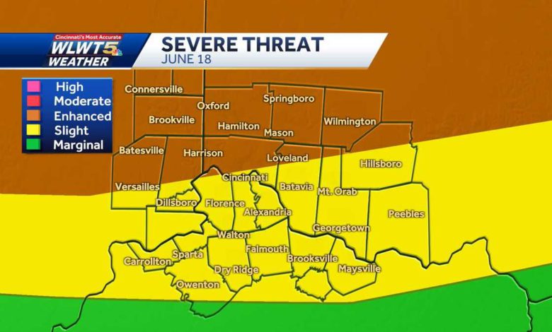
Be ready for storms to dive from north to south after around 5 or 6 p.m.
The strongest winds and greatest potential for damage will be to the north of the Interstate 275 loop.
Rounds of torrential rain will move through overnight. There will be lots of lightning and the possibility for some hail, too.
While the threat for severe weather continues with strong wind gusts, it will be lower overnight, and we are still looking at a flood concern into early Saturday morning.
A Flood Watch starts 6 p.m. Friday night and continues through noon on Saturday.
There will be some towns that see 2 to 4 inches of rainfall by that point.
Highs this weekend will be between 85 and 90 degrees, with very humid conditions.
Highs will be slightly cooler Saturday due to the morning rain, before drier weather takes over for the afternoon.
Scattered rain will still be a possibility and even on Father's Day with just a few pop-up downpours. Nights will be muggy with lows around 70.
Another cold front will bring widespread showers and storms Monday afternoon with some of those potentially severe, before much cooler weather arrives again Monday night into Tuesday.
Source link