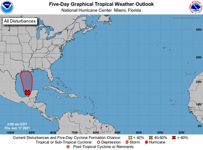
- Landfall for the system in the Gulf of Mexico could be anywhere from the Texas-Louisiana border to the western part of the Florida Panhandle.
- Louisiana could see up to 20 inches of rain over three days.
- An Air Force Reserve Unit reconnaissance aircraft is scheduled to investigate the disturbance later Thursday if necessary.
VERO BEACH, Fla. — An ominous weather system slowly rolling toward the Gulf of Mexico on Thursday was threatening to strengthen into Tropical Storm Claudette before slamming onto shore across four states.
Coastal Louisiana, Mississippi, Alabama, Georgia and the Florida panhandle could face heavy rains and flooding Friday and into the weekend, AccuWeather senior meteorologist Rob Miller said.
Parts of Louisiana could see up to 20 inches of rain over three days.
"A hurricane is unlikely," Miller said. But he added that "a mere tropical depression or tropical storm can unleash a tremendous amount of rain once over land, and that remains the primary concern."
Though by nightfall Thursday, the system remained poorly organized, the National Hurricane Center issued a tropical storm warning for southeast Louisiana to the Alabama-Florida border.
AccuWeather meteorologists have pinpointed late Friday to Saturday as the most likely time frame, and the Louisiana coastline is the most likely place for landfall. However, landfall may occur anywhere from near the Texas-Louisiana border to the western part of the Florida Panhandle, Miller said.
NOAA predicts another busy Atlantic hurricane season: Up to 20 named storms
The National Hurricane Center said an Air Force Reserve Unit reconnaissance aircraft was scheduled to investigate the disturbance if necessary.
"The low should begin to move northward by this afternoon, and a tropical or subtropical depression is likely to form by late tonight or on Friday," the hurricane center warned. "Regardless of development, a high risk of rip currents is expected by Friday, with the potential for very heavy rain, a few brief tornadoes, high surf and minor coastal flooding this weekend."

Forecasters are urging residents not to focus solely on the forecast point of landfall, as the impact from tropical storms are often spread out.
"Since southwesterly wind shear is already affecting the feature ... much of and perhaps all of the downpours will occur on the eastern side of the storm center and may extend across hundreds of miles," Miller said.
Weather conditions are expected to deteriorate from the upper Texas coast through the Florida Panhandle on Friday with the potential for tropical storm conditions for a time this weekend.
"The storm, regardless of strength, has the potential to deliver rainfall rates of 1-2 inches per hour over a several-hour period," Miller said.
Earlier this week:Tropical Storm Bill roars off Carolina coast as hurricane season awakens in the Atlantic Basin
Abnormal temperatures are baking the Western US in triple digits. These heat waves could become the new normal.
The heaviest rainfall was forecast for southern and eastern Louisiana, southern Mississippi, southwestern Alabama and the western part of the Florida Panhandle. This zone has the highest potential to pick up 8 to 12 inches of rain over a 24- to 48-hour period – and possibly 20 inches in 72 hours.
However, a broad area of 2 to 8 inches of rain is possible from near the Texas and Louisiana border to the eastern part of the Florida Panhandle and perhaps as far to the north as the southern border of Tennessee.
Earlier in the week, forecasters had been monitoring three disturbances at the same time, including one that briefly became Tropical Storm Bill off the Carolina coast.
This hurricane season could bring a record sixth consecutive year of above-normal activity. The National Oceanic and Atmospheric Administration predicted that up to 20 named storms will develop, starting with tropical storms driving wind speeds of 39 mph or higher. Storms become hurricanes when winds reach 74 mph.
As many as 10 hurricanes could form, NOAA said, with three to five possibly "major" hurricanes with wind speeds of 111 mph or higher. An average season typically spawns seven hurricanes and peaks in August and September.
Last year, NOAA predicted 13 to 19 named tropical storms would spin up, of which six to 10 would be hurricanes. Instead, a record 30 named storms formed, including 14 hurricanes, of which seven were major.
Bacon reported from Arlington, Virginia
Hurricane and tropical storm tracker
Source link


