
The Ohio River is on the rise. A near 22 inches of snow fell in February, adding up to 78% of our winter's snow total. With temperatures on the rise, signs of the snow have almost completely melted away. That snowmelt coupled with incoming rain starts bringing the river out of its banks. The river's been slowly rising for a few days, but it hits the action stage at Cincinnati by 7 a.m. Monday. There is a 10-25% chance the river exceeds minor flood levels between March 2-16. The minor flood stage starts at 52 feet. Here are the projections for March 1-3: 7 a.m. Monday: 41.2' 7 a.m. Tuesday: 47.2'7 a.m. Wednesday: 50.1'7 a.m. Thursday: 51'Sunday's incoming rain is likely going to be heaviest. Some areas south of the river get 1-2 inches. If the axis of heavy rain shifts closer to or north of the river, that could have an impact on river levels. Other rivers around Greater Cincinnati could get swollen, as well. The Ohio Brush Creek near West Union is at 3.94 feet as of Saturday afternoon but is projected to crest at 12.9 feet Monday morning. Ohio River at Maysville was at 36.8 feet as of Saturday afternoon. It is projected to hit 48.4 feet by Wednesday morning and 50.1 feet overnight into Thursday morning.The Ohio River at Meldahl Dam is at 32.14 feet as of Saturday afternoon. It will hit 49.5 feet late Tuesday night/early Wednesday morning and crests at 50.7 feet by 7 p.m. Wednesday.The Licking River at Catawba rises to 35.9 feet overnight Monday-Tuesday morning.The Licking River at Falmouth is expected to get to 30.5 feet overnight Monday-Tuesday morning. The Licking River at McKinneysburg crests at 33.4 feet at 1 p.m. Tuesday.The Eagle Creek near Glencoe is at 4.05 feet as of Saturday afternoon and crests at 15.7 feet overnight Sunday-Monday morning.Recently, the Ohio River made it to 60.53' at the Cincinnati gauge in 2018 (pictured above). That was the highest the river has been since it hit 64.7 feet in 1997. The highest the river has been recorded was 80 feet in 1937. Keep checking back for the latest river data and river flooding concerns.
The Ohio River is on the rise.
A near 22 inches of snow fell in February, adding up to 78% of our winter's snow total. With temperatures on the rise, signs of the snow have almost completely melted away. That snowmelt coupled with incoming rain starts bringing the river out of its banks.
The river's been slowly rising for a few days, but it hits the action stage at Cincinnati by 7 a.m. Monday. There is a 10-25% chance the river exceeds minor flood levels between March 2-16. The minor flood stage starts at 52 feet. Here are the projections for March 1-3:
- 7 a.m. Monday: 41.2'
- 7 a.m. Tuesday: 47.2'
- 7 a.m. Wednesday: 50.1'
- 7 a.m. Thursday: 51'
Sunday's incoming rain is likely going to be heaviest. Some areas south of the river get 1-2 inches. If the axis of heavy rain shifts closer to or north of the river, that could have an impact on river levels.
Other rivers around Greater Cincinnati could get swollen, as well.
- The Ohio Brush Creek near West Union is at 3.94 feet as of Saturday afternoon but is projected to crest at 12.9 feet Monday morning.
- Ohio River at Maysville was at 36.8 feet as of Saturday afternoon. It is projected to hit 48.4 feet by Wednesday morning and 50.1 feet overnight into Thursday morning.
- The Ohio River at Meldahl Dam is at 32.14 feet as of Saturday afternoon. It will hit 49.5 feet late Tuesday night/early Wednesday morning and crests at 50.7 feet by 7 p.m. Wednesday.
- The Licking River at Catawba rises to 35.9 feet overnight Monday-Tuesday morning.
- The Licking River at Falmouth is expected to get to 30.5 feet overnight Monday-Tuesday morning.
- The Licking River at McKinneysburg crests at 33.4 feet at 1 p.m. Tuesday.
- The Eagle Creek near Glencoe is at 4.05 feet as of Saturday afternoon and crests at 15.7 feet overnight Sunday-Monday morning.
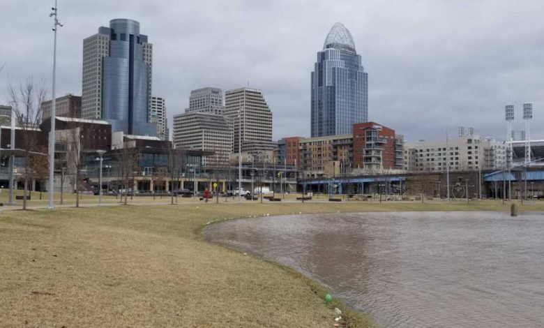
Recently, the Ohio River made it to 60.53' at the Cincinnati gauge in 2018 (pictured above). That was the highest the river has been since it hit 64.7 feet in 1997. The highest the river has been recorded was 80 feet in 1937.
Keep checking back for the latest river data and river flooding concerns.
Source link


