
Our first snow of the new year will bring light accumulation for most, but the timing of the snow is likely to cause slowdowns to travel in the afternoon and evening Thursday.CLOSURES AND DELAYS // LIVE RADAR // LATEST WEATHER ALERTSWe're off to a very cold start with temperatures in the teens and wind chills in the low single digits. Clouds will quickly build in with snow expected across Northern Kentucky by late morning and beginning after 12 p.m. around the Cincinnati metro area.Around an inch of snow is expected around the I-275 loop with amounts up to 2 inches across parts of Northern Kentucky. Less snow is likely farther north, with Hamilton and Oxford expecting a half-inch or less.There is a Winter Weather Advisory from 10 a.m. to 10 p.m. for Brown and Adams counties in Ohio and Carroll, Gallatin, Owen, Grant, Pendleton, Bracken, Mason and Robertson counties in Kentucky.While for much of Cincinnati these amounts are minor, slick travel is still possible, especially deeper into Kentucky, so be careful and allow for extra time on the roads. Track snow plow activity in your areaAny snow will end before 8 p.m., leaving bitterly low wind chills that will settle in overnight and Friday morning near 0 degrees and even a little below as skies clear and lows fall to the single digits. Sunshine returns Friday with highs in the mid-20s and lows in the mid-teens.Expect a warm-up over the weekend. Highs will reach the low-to-mid 40s Saturday under sunshine, with rain arriving Saturday night and showers lingering into Sunday. Lows Saturday night will not be as cold with lows in the mid to upper 30s. Highs Sunday will be in the mid-40s before another blast of frigid air crashes lows Sunday night back into the teens again.
Our first snow of the new year will bring light accumulation for most, but the timing of the snow is likely to cause slowdowns to travel in the afternoon and evening Thursday.
CLOSURES AND DELAYS // LIVE RADAR // LATEST WEATHER ALERTS
We're off to a very cold start with temperatures in the teens and wind chills in the low single digits.
Clouds will quickly build in with snow expected across Northern Kentucky by late morning and beginning after 12 p.m. around the Cincinnati metro area.
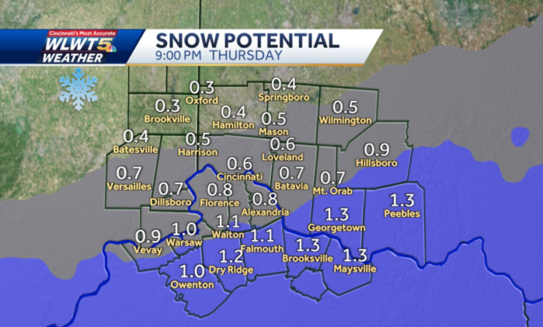
Around an inch of snow is expected around the I-275 loop with amounts up to 2 inches across parts of Northern Kentucky. Less snow is likely farther north, with Hamilton and Oxford expecting a half-inch or less.
There is a Winter Weather Advisory from 10 a.m. to 10 p.m. for Brown and Adams counties in Ohio and Carroll, Gallatin, Owen, Grant, Pendleton, Bracken, Mason and Robertson counties in Kentucky.
While for much of Cincinnati these amounts are minor, slick travel is still possible, especially deeper into Kentucky, so be careful and allow for extra time on the roads.
Track snow plow activity in your area
Any snow will end before 8 p.m., leaving bitterly low wind chills that will settle in overnight and Friday morning near 0 degrees and even a little below as skies clear and lows fall to the single digits.
Sunshine returns Friday with highs in the mid-20s and lows in the mid-teens.
Expect a warm-up over the weekend. Highs will reach the low-to-mid 40s Saturday under sunshine, with rain arriving Saturday night and showers lingering into Sunday. Lows Saturday night will not be as cold with lows in the mid to upper 30s. Highs Sunday will be in the mid-40s before another blast of frigid air crashes lows Sunday night back into the teens again.
Source link


