- The 'bomb cyclone' storms that drenched California are heading toward the East Coast.
- New Jersey and New York declared states of emergency on Monday night.
- Two people were killed near Seattle when a tree fell on a vehicle during the weekend storms.
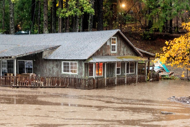
A broad swath of California was under siege Monday from high winds and historic rains fueled by an iconic "bomb cyclone" that unleashed mudslides and flooding and triggered widespread power outages.
The drought-plagued West needs the rain, but not like this. Meteorologists say the bomb cyclone – a rapid drop in atmospheric pressure – helped drive a long, wide plume of precipitation dubbed an "atmospheric river" from the Pacific Ocean onto the West Coast. In California, power lines tumbled and more than 100,000 homes and businesses remained in the dark Monday.
Another 50,000 power customers were affected across Washington state, where two people were killed when a tree fell on a vehicle near Seattle.
"The same massive storm that is currently bringing heavy rain, snow and strong winds to the Western states is expected to slowly move eastward across the country," AccuWeather senior meteorologist Brett Anderson warned.
What is going on with the weather?Tackle deep climate issues and current events with the Climate Point newsletter
The front line of the storms that began late last week in California already have marched through much of the nation's midsection. A suspected tornado damaged buildings and knocked out power in communities along the border between Illinois and Missouri. The severe weather also was blamed for damage across multiple states.
The East Coast was bracing for the storms. AccuWeather meteorologist Joseph Bauer warned that heavy rains and winds could choke New York City's morning commute Tuesday; 3 to 5 inches of rain is possible over the next couple of days. And the latest storms slamming California could bring more foul weather to the East by week's end.
The National Weather Service issued a flash flood warning for parts of northeast New Jersey and southeast New York due to thunderstorms on Monday night. 1 to two inches of rain could fall within an hour, according to the service.
"Take this seriously," New York Mayor Bill de Blasio said. "Use mass transit for your commute tonight and tomorrow. Don't walk or drive into flooded areas."
Thethreat of stormy weather prompted New York Gov. Kathy Hochul and New Jersey Gov. Phil Murphy to declare states of emergency beginning Monday night.

"In preparation for the Nor’easter, I’m declaring a State of Emergency beginning at 8:00 PM tonight. Severe weather conditions will impact the state starting tonight through the next several days," Murphy said on Twitter.
Earlier Monday, Hochul told state agencies that work in emergency response to prepare assets for deployment across impacted regions.
California was seeing incomprehensible rainfall totals. The wettest wonder could be in Mount Tamalpais in Marin County, 20 miles north of San Francisco, where the National Weather Service measured more than 16 inches of rain over a 48-hour period. St. Helena, a city of 6,100 in wine country, saw more than 10 inches.
"Looks like 4.02 inches of rain for the calendar day in downtown SF," the Bay Area weather service tweeted. "By far the wettest Oct day ever ... 4th Wettest day EVER in SF with records back to Gold Rush."
Parts of San Francisco were swamped, and Mayor London Breed urged residents to call 311 to get help for people in need of shelter and 911 for medical emergencies.
"Help your community by checking in virtually with friends and family who may need assistance during extreme weather," Breed tweeted.
Downtown Sacramento also set a 24-hour record with more than 5 inches of rain, and a shelter was set up at City Hall.
"City Hall also belongs to the people who are having the hardest of hard times," Mayor Darrell Steinberg said. "I'm really proud of the fact that we are opening up the people's building to bring people indoors."
Heavy snow pounded high elevations of the Sierra Nevada. Several areas, including the Santa Cruz Mountains and parts of western Santa Barbara County, issued evacuation orders because of their proximity to wildfire burn scars.
Heavy rain swept into much of Southern California later in the day.
West Coast's 'bomb cyclone' could become nor'easter
The storms originated over the Pacific Ocean last week and were moving west to east across the nation, AccuWeather said. Severe thunderstorms were forecast for the Ohio and Tennessee River valleys, and rain and showers will spread farther north. By Tuesday, the storm will strengthen as it moves across southern New England, bombarding residents with heavy rain and increasingly high winds, AccuWeather said.
“An early season tempest could bring a wind-driven, chilly rain to portions of the Northeast from Monday through Wednesday," AccuWeather meteorologist Randy Adkins said.
Bomb cyclone, atmospheric river blast West Coast: 2 dead in Seattle area, hundreds of thousands without power
Flooding downpours will reach from southern Maine to eastern New York and cities such as Philadelphia, Boston and Worcester, Massachusetts, which are expected to see up to 3 to 4 inches of rain. Totals reaching 8 inches were expected in some areas as the storm intensifies off the coast, AccuWeather forecast.
Winds are expected to gust from 40 to 60 mph Tuesday and Wednesday from the Jersey Shore to the southern shore of Nova Scotia. Cities such as Provincetown, Plymouth and Boston in Massachusetts could experience wind gusts as high as 80 mph Tuesday night, AccuWeather said.
By Thursday, the nor'easter will move out ot sea – but another storm built on remnants from the "bomb cyclone" that walloped California on Sunday was expected to approach from the west, dousing East Coast trick-or-treaters over the weekend.
Contributing: Christal Hayes, USA TODAY; The Associated Press


