The National Hurricane Center upgraded some tropical storm watches to warnings Friday as Potential Tropical Cyclone One crept closer to Florida.A tropical storm warning means that tropical storm conditions are expected somewhere within the warning area within 36 hours.As of 11 p.m. Friday, the system was located about 185 miles southwest of Fort Myers, Florida.The storm has maximum sustained winds of 40 mph and is moving northeast at 12 mph.LATEST CONELATEST MODELSATLANTIC SATELLITEWhat is a potential tropical cyclone?A potential tropical cyclone is a term used by the National Hurricane Center to issue watches and warnings for a storm system that is expected to develop as it approaches land.The National Hurricane Center couldn't issue watches and warnings until a tropical storm had actually developed, which limited the time to give people proper warning. The NHC is predicting a 90% chance this cluster of storms will form into either a depression or tropical storm over the next 48 hours.The latest guidance from forecasters is that Potential Tropical Cyclone One is picking up speed towards the northeast and dropping heavy rain across Western Cuba and Southern Florida.If the system strengthens and reaches sustained winds of 39 mph or higher, it would be named Alex, the first named storm of the 2022 hurricane season. This system's maximum sustained winds are currently at 35 mph.A cyclone is also another name for a hurricane, but its name differs depending on where in the world it forms.All signs point to a lot of rain across Florida's southern areas with gusty winds to potentially tropical storm strength.Parts of Central Florida are under a tropical storm warning as of Friday evening.The worst of the weather in Central Florida is expected between 2 p.m. Saturday and 2 a.m. Sunday.The 11 p.m. advisory warns that Central Florida, South Florida, and the Florida Keys could see 4 to 8 inches of rain with an isolated maximum of 12 inches across South Florida and in the Keys. CNN contributed to this report.
The National Hurricane Center upgraded some tropical storm watches to warnings Friday as Potential Tropical Cyclone One crept closer to Florida.
A tropical storm warning means that tropical storm conditions are expected somewhere within the warning area within 36 hours.
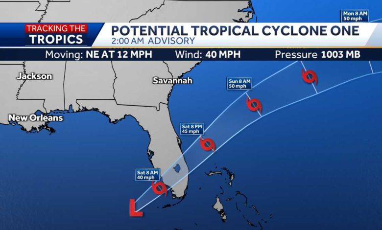
As of 11 p.m. Friday, the system was located about 185 miles southwest of Fort Myers, Florida.
The storm has maximum sustained winds of 40 mph and is moving northeast at 12 mph.
LATEST CONE
LATEST MODELS
ATLANTIC SATELLITE
What is a potential tropical cyclone?
A potential tropical cyclone is a term used by the National Hurricane Center to issue watches and warnings for a storm system that is expected to develop as it approaches land.
The National Hurricane Center couldn't issue watches and warnings until a tropical storm had actually developed, which limited the time to give people proper warning.
The NHC is predicting a 90% chance this cluster of storms will form into either a depression or tropical storm over the next 48 hours.
The latest guidance from forecasters is that Potential Tropical Cyclone One is picking up speed towards the northeast and dropping heavy rain across Western Cuba and Southern Florida.
If the system strengthens and reaches sustained winds of 39 mph or higher, it would be named Alex, the first named storm of the 2022 hurricane season. This system's maximum sustained winds are currently at 35 mph.
A cyclone is also another name for a hurricane, but its name differs depending on where in the world it forms.
All signs point to a lot of rain across Florida's southern areas with gusty winds to potentially tropical storm strength.
Parts of Central Florida are under a tropical storm warning as of Friday evening.
The worst of the weather in Central Florida is expected between 2 p.m. Saturday and 2 a.m. Sunday.
The 11 p.m. advisory warns that Central Florida, South Florida, and the Florida Keys could see 4 to 8 inches of rain with an isolated maximum of 12 inches across South Florida and in the Keys.
CNN contributed to this report.
Source link


