Tuesday weather outlook: Two days of heat to close out summer

Updated: 7:35 AM EDT Sep 20, 2022
CONDITIONS. EVERYONE ALWAYS LOOKS FORWARD TO THIS. COLIN: IF YOU ARE ABLE TO GET OUT AND WALK THE PARKS, IT IS A GREAT TIME TO DO IT. WEATHER BROKEN SIDE -- THE WEATHER WILL COINCIDE WITH THE FALL CALENDAR. RANDI: MY WAS VERY EXCITED. I SAID, DID YOU LOOK AT THURSDAY? HE SAYS, WOW, YOU ARE NOT KIDDING. KELLY: IT IS GOING TO BE SO NICE. RANDI: LAST YEAR WE GOT ROBBED OF COOL FALL COLORS, EVERYTHING TURNED BROWN AND FELL AT ONCE. KELLY: WE HAD STORMS. RANDI: RIGHT. ON THURSDAY. WE ARE SWITCHING FROM SUMMER TO ON THE CALENDAR AT THE FORECAST. TOMORROW, TEMPERATURES STILL TRENDING UPPER 80’S. SOME SPOTS, MID OR LOW 90’S. WE WILL END SUMMER WITH THE FULL ON SUMMERFIELD. IF YOU ARE A SUMMERFIELD -- IF YOU ARE A SUMMER PERSON, THE NEXT FEW DAYS ARE FOR YOU. FOR THOSE TRYING TO GET INTO FALL MENTALLY, CHECK OUT THURSDAY AND FRIDAY AND NEXT WEEK. HIGHS IN THE 60’S AND 70’S NEXT WEEK. OUR VIEW FROM CITY CAN -- CITY CAMERA IS LOOKING GOOD. THERE ARE SPOTS WHERE VISIBILITY IS DOWN TO BELOW A QUARTER-MILE. WE HAVE THE TEMPERATURE AND THE DEW POINT FOR SAM, THE WINDS ARE,. YOU CAN EXPECT TO SEE SOME FOGGY SPOTS THROUGH 9:00 A.M.. THROUGH THE MORNING RUSH, ESPECIALLY IN OUR RIVER VALLEY AREAS, WE HAVE THICKER FOGS. TEMPERATURES IN THE 60’S. AS WE HEADED TO THE AFTERNOON, WE HEADING OUT -- WE HANG OUT IN THE MID TO UPPER 80’S. THE HUMIDITY JUMPS FOR THE LAST DAY OF SUMMER TIME TOMORROW. WE ARE READY FOR FALL. INFRASTRUCTURE ON THURSDAY IN THE CALENDAR AND AND IN THE FORECAST. OUR FIRST FALL FRONT ARRIVES THURSDAY NIGHT INTO -- WESTON NIGHT INTO THURSDAY MORNING. -- WEDNESDAY NIGHT INTO THURSDAY MORNING. BEHIND THAT LINE, MORNINGS IN THE 40’S AND 50’S AND AFTERNOONS IN THE 60’S AND 70’S. THIS IS KNOWN TOMORROW, FEELING THE HEAT AND HUMIDITY. BY THE TIME THE SUN GOES DOWN, THE RATE CHANCES GO UP. BETTER CHANCES EARLY WARNING THURSDAY, 4:00 OR 5:00 A.M. AS THE FRONT PASSES TO THE SOUTH. THAT LESS HUMID AIR BUILDS IN AND STICKS WITH US THROUGH THE WEEKEND. TODAY, 86 DEGREES. EARLY FOG, TURNING SUNNY. MORE HUMIDITY IN PLAY TOMORROW AS WE MAKE IT INTO THE 90’S. IT WILL FEEL LIKELY MID UPPER 90’S AND THEN FOLLOW ARRIVES THURSDAY. ARE TEMPERATURES DROPPING INTO THE 60’S AND 70’S, FEELING NICE AND COMFORTABLE INTO THE WEEKEND. KATIE, HOW ARE THE ROADS THIS MORNING? KATI
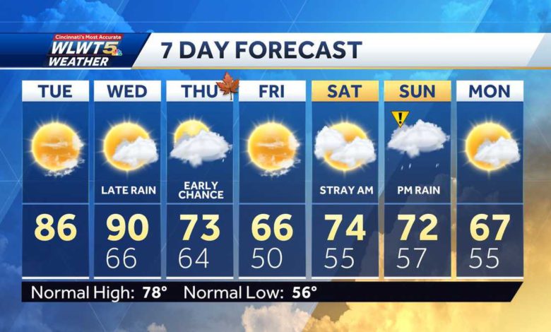
It doesn't always work out like this, but when fall arrives on Thursday, so will the crisp fall air.Up until that point, however, the last two days of summer will be bringing the heat!Plan on a muggy day. We are starting with some areas of thick fog: That should clear in the 9 a.m. hour.Sunshine will eventually take over this afternoon, with highs headed to the upper 90s.Wednesday is the final day of summer and the high will be around 90! With increased humidity, it will feel like a throwback to July.Fall officially arrives on the calendar on Thursday and the weather knows it, too! A cold front passes by first thing Thursday morning and temperatures and humidity drop off quickly.This front will bring a chance for scattered rain or a storm from sunset Wednesday night through the early morning on Thursday.We'll fall back to the 60s and 70s for highs to close out the week.Highs will be in the 70s this weekend with maybe a sprinkle early Saturday, then a better chance for rain to close out the weekend on Sunday afternoon.
It doesn't always work out like this, but when fall arrives on Thursday, so will the crisp fall air.
Up until that point, however, the last two days of summer will be bringing the heat!
Plan on a muggy day. We are starting with some areas of thick fog: That should clear in the 9 a.m. hour.
Sunshine will eventually take over this afternoon, with highs headed to the upper 90s.
Wednesday is the final day of summer and the high will be around 90! With increased humidity, it will feel like a throwback to July.
Fall officially arrives on the calendar on Thursday and the weather knows it, too! A cold front passes by first thing Thursday morning and temperatures and humidity drop off quickly.
This front will bring a chance for scattered rain or a storm from sunset Wednesday night through the early morning on Thursday.
We'll fall back to the 60s and 70s for highs to close out the week.
Highs will be in the 70s this weekend with maybe a sprinkle early Saturday, then a better chance for rain to close out the weekend on Sunday afternoon.
Source link