Air Quality Alert: Wildfire smoke settles over Cincinnati causing haze, fog

Updated: 5:58 PM EDT Jun 28, 2023
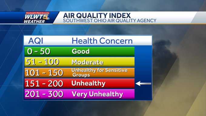
KEVIN HAS A COUPLE OF FRIENDS WHO THEY’VE EXPERIENCING THIS VERY THING. I WAS JUST SAYING I HAVE TWO FRIENDS, ONE FINALLY GOT THEIR LUGGAGE. NOW THE. OTHER ONE’S BEEN WAITING TWO DAYS. SO IT’S A REAL THING THAT’S HAPPENING. IT’S AN EXPENSIVE HASSLE, YOU KNOW, YOU GET THERE, YOU HAVE TO BUY STUFF. MORE FRUSTRATING NOT JUST THE LUGGAGE THING, BUT LIKE WHEN THE PLANE’S NOT THERE AND YOU’RE WONDERING, OKAY, DO THEY HAVE A CREW? WHEN IS THE PLANE GOING TO ARRIVE? AND THEN THEY TELL YOU. AND THEN IT’S ALWAYS HOURS AND HOURS LATER. THAT’S REALLY TOUGH TO DEAL WITH. SO A LITTLE TIP. WHAT I ALWAYS DO, ALWAYS BRING AT LEAST A SMALL BAG OF THE NECESSITY IS IN YOUR CARRY ON IF IT’S YOUR OF COURSE YOU CAN ALWAYS GET TO PRECIOUS THINGS LIKE BUT SOMETIMES YOU WANT A FEW OF THOSE ITEMS THAT YOU JUST PERSONALLY WANT RIGHT THERE WITH YOU. ALL RIGHT. IN THE MEANTIME, I KNOW A LOT OF YOU OUT THERE ARE CONCERNED ABOUT THE WEATHER TODAY. YOU’RE SEEING THE SMOG, MAYBE FEELING IT IN YOUR THROAT. UNFORTUNATELY, IT’S GOING TO LINGER AT LEAST THROUGH TONIGHT. YEAH, THE WORST AIR QUALITY WE’VE SEEN IN CINCINNATI IN ALMOST FIVE YEARS SINCE THEY FIRST STARTED KEEPING RECORDS OF OUR AIR QUALITY BACK AROUND 2000. SO, YEAH, WE’VE BLOWN RIGHT PAST THAT NUMBER. AND THAT’S WHAT THIS GRAY REPRESENTS. AIR QUALITY ISSUES EXPECTED TO RIGHT ON INTO YOUR THURSDAY AND IT’S NOT JUST HERE CLOSE TO HOME IT’S ALL OF THE MIDWEST. IT’S THE ENTIRE GREAT LAKES REGION ALL THE WAY TO THE EAST COAST. AND YOU KNOW WHAT? OF COURSE, THE POOR AIR, THE REDUCTION IN VISIBILITIES, NOT HELPING THE AIRLINES EITHER. SO IT’S KIND OF A DOUBLE WHAMMY HERE BECAUSE YOU’VE GOT LOW VISIBILITY AT EASE WITH AIR QUALITY RESTRICTIONS AND THEN YOU’RE GOING TO HAVE THUNDERSTORMS GOING INTO THE WEEKEND. I’LL TALK ABOUT THAT STORM COMPONENT HERE IN JUST A SECOND. BUT RIGHT NOW, OUR AIR QUALITY REMAINS UNHEALTHY FOR EVERYONE AS WE’VE BEEN TALKING ABOUT. SO YOU’LL WANT TO LIMIT THE AMOUNT OF TIME YOU SPEND OUTDOORS. TODAY’S AVERAGE HAS BEEN RIGHT AROUND 188, BUT THERE HAVE A NUMBER OF SENSORS. FOR EXAMPLE IN THE LOWER PRICE HEEL AREA OVER NEAR THE TAFT EXIT. CARTHAGE AREA AS WELL. WE’VE SEEN NUMBERS AS HIGH AS 199 TO ALMOST CLOSE TO 200, MAKING THE AIR ALMOST HAZARDOUS FOR SOME AREA. SO, AGAIN, JUST A NASTY LOOK AS YOU CAN SEE HOW YOU’VE REALLY OBSCURED THE SKYLINE HERE INTO THE COVINGTON AREA. JUST AN ASTONISHING SHOT AS YOU LOOK ACROSS THE RIVER THIS AFTERNOON. ON THE OTHER SIDE, IT FEELS GREAT OUT THERE RIGHT ONLY IN THE LOW EIGHTIES HUMIDITY ON THE LOW SIDE DO POINTS COMFORTABLY LOW. THAT’S ALL GOING TO CHANGE. IT WILL CHANGE WHEN OUR WINDS SWITCH AROUND. SO FOR NOW, THE SMOKE IS KIND OF TRAPPED IN THE OHIO VALLEY. HIGH PRESSURE BASICALLY KEEPING NICE AND DRY. BUT ONCE THE WINDS SWITCH TO THE SOUTH ON, FORTUNATELY, NOT ONLY WILL THEY GET THE SMOKE OF HERE, BUT THAT WILL ALSO START. LEAVE US SUSCEPTIBLE TO THE THUNDERSTORM CLUSTERS THAT WILL ROLLING OUT OF THE MIDWEST, STARTING PROBABLY AS EARLY AS TOMORROW EVENING AND NIGHT. SO WHAT WE KNOW HEADING INTO THE WEEKEND IS THAT WHEN IT’S NOT RAINING, IT’S GOING TO BE STEAMY. THIS WILL PROBABLY BE ONE OF THE STEAMIEST WEEKENDS WE’VE HAD SO FAR SINCE THE SPRING BECAUSE. WE HAVEN’T HAD A LOT OF HUMIDITY THAT CHANGES THIS WEEKEND. IT’S GOING TO BE A OPPRESSIVELY HUMID AND HOT. THE OTHER CONCERN, THE THREAT FOR THUNDERSTORMS WARMS, UNFORTUNATELY, IT’S THE AND LOCATION OF ONE OF THOSE CLUSTERS THAT WILL MAKE IT A LITTLE DIFFICULT. RIGHT NOW, 80 AND SPRING OF 80 IN MAYSVILLE. SO VERY COMFORTABLE FOR LATE JUNE OUTSIDE SHOULD BE NICE EVENING JUST WITH THE POOR AIR QUALITY. TEMPERATURES OVERNIGHT WILL GET DOWN INTO THE LOW TO MID SIXTIES US. SO LET ME SHOW YOU THE SATELLITE AND RADAR. NOTICE THE SHOWERS AND STARTING TO DIVE ACROSS THE CORN THROUGH ILLINOIS. THAT’S THE THAT IN TIME WILL BEGIN TO TAKE AIM AT THE OHIO RIVER VALLEY AND IT WILL START WITH OUR FIRST THREAT FOR STRONG TO SEVERE STORMS ON FRIDAY. RIGHT NOW, TRI-STATE UNDER A SLIGHT RISK FOR STRONG SEVERE STORMS. I THINK WE COULD SEE BOUTS OF STORMS OVER WEEKEND. SO ANY ONE OF THESE CLUSTERS COULD PACK THE THREAT FOR SEVERE WEATHER. THAT’S WHY YOU’RE GOING TO HAVE TO STAY WEATHER ALERT. AND I CAN JUST TELL YOU, JUST BE PREPARED FOR INTERRUPTIONS THIS WEEKEND. SMOKY TONIGHT, A LITTLE MILDER, 60 FOR TOMORROW. ANOTHER AIR QUALITY ALERT. WE’LL KEEP AN EYE OUT FOR THE THREAT FOR STORMS TOMORROW NIGHT. RIGHT NOW, I’M GOING TO KEEP THE DAYTIME DRY TOMORROW. I THINK THE THREAT FOR STORMS GENERALLY MOVES IN HERE LATER TOMORROW NIGHT. HERE’S YOUR SEVEN DAY FORECAST. SO THERE YOU HAVE IT, FRIDAY, SATURDAY, SUNDAY, BOTH ALL THREE WEATHER IMPACT DAYS INTO EARLY NEXT WEEK, MIKE AND CHERI. AND AGAIN, IT BE RAINING THE ENTIRE TIME, BUT IT DOES. SOME OF THOSE STORMS COULD BE INTENSE. THE GOOD NEWS IS THAT WITH US BEING IN A DROUGHT, WE SHOULD GET SO
Air Quality Alert: Wildfire smoke settles over Cincinnati causing haze, fog
Updated: 5:58 PM EDT Jun 28, 2023
Canadian wildfire smoke and clouds keep our sky hazy for the next day or so. Swifties and sports fans, keep an eye on the weekend forecast! Rain and storms likely impact an event at some point this weekend. LIVE RADAR // LATEST WEATHER ALERTSAn Air Quality Alert is in effect for much of Greater Cincinnati Wednesday. Try to limit time outside, especially if you fall in the 'sensitive' groups.What should you do when an Air Quality Alert is issued?Take the bus, carpool, bike, or walk instead of drivingRefuel your vehicle after 6 p.m., do not top off when refueling, and tighten the gas capDo not idle your vehicleCombine trips or eliminate unnecessary vehicle tripsKeep your vehicle maintained with properly-inflated tires and timely oil changesAvoid use of gasoline-powered lawn equipment on Air Quality Alert daysAvoid use of oil-based paints and stains on Air Quality Alert daysNever burn leaves or other yard trimmingsAlways burn clean, seasoned wood in outdoor fire pits, fireplaces, and wood stovesAvoid using fire pits or fireplaces for non-essential home heating on Air Quality Alert daysConserve electricityWednesday we have smoke and fog to start the day. Some filtered sun likely leads to highs in the low to middle 80s. Thursday remains mainly dry at this point (maybe a shower in Indiana) with high temperatures jumping and humidity slowly increasing. Highs warm to the middle and upper 80s.Highs Friday top out close to 90 degrees and there will be thunderstorms in the area, including downtown. Whether you're dressing for your favorite Taylor Era or going to Great American, get ready for heat and potential lightning. Midnight rain? At some point this weekend, most likely.Scattered thunderstorms redevelop Saturday afternoon. Highs climb near 90 as humidity climbs yet again. At some point this weekend, storms could even become strong. It rains when Taylor's here and rains when Taylor's gone. Sunday brings much of the same with afternoon storms that could become strong.
Canadian wildfire smoke and clouds keep our sky hazy for the next day or so. Swifties and sports fans, keep an eye on the weekend forecast! Rain and storms likely impact an event at some point this weekend.
LIVE RADAR // LATEST WEATHER ALERTS
This content is imported from Twitter.
You may be able to find the same content in another format, or you may be able to find more information, at their web site.
An Air Quality Alert is in effect for much of Greater Cincinnati Wednesday. Try to limit time outside, especially if you fall in the 'sensitive' groups.
What should you do when an Air Quality Alert is issued?
- Take the bus, carpool, bike, or walk instead of driving
- Refuel your vehicle after 6 p.m., do not top off when refueling, and tighten the gas cap
- Do not idle your vehicle
- Combine trips or eliminate unnecessary vehicle trips
- Keep your vehicle maintained with properly-inflated tires and timely oil changes
- Avoid use of gasoline-powered lawn equipment on Air Quality Alert days
- Avoid use of oil-based paints and stains on Air Quality Alert days
- Never burn leaves or other yard trimmings
- Always burn clean, seasoned wood in outdoor fire pits, fireplaces, and wood stoves
- Avoid using fire pits or fireplaces for non-essential home heating on Air Quality Alert days
- Conserve electricity
Wednesday we have smoke and fog to start the day. Some filtered sun likely leads to highs in the low to middle 80s. Thursday remains mainly dry at this point (maybe a shower in Indiana) with high temperatures jumping and humidity slowly increasing. Highs warm to the middle and upper 80s.
Highs Friday top out close to 90 degrees and there will be thunderstorms in the area, including downtown. Whether you're dressing for your favorite Taylor Era or going to Great American, get ready for heat and potential lightning. Midnight rain? At some point this weekend, most likely.
Scattered thunderstorms redevelop Saturday afternoon. Highs climb near 90 as humidity climbs yet again. At some point this weekend, storms could even become strong. It rains when Taylor's here and rains when Taylor's gone. Sunday brings much of the same with afternoon storms that could become strong.
Source link