Thursday weather planner: Summer heat returns, as does the possibility for evening showers

Updated: 7:41 AM EDT Jun 15, 2023
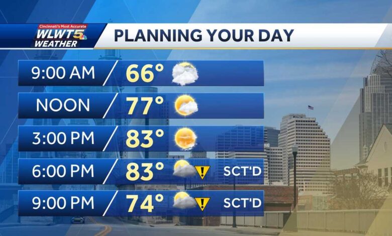
I KNOW AS WE GET CLOSER TO THE WEEKEND, YOU START TO MAKE ALL OF YOUR PLANS. IT IS ALSO FATHER’S DAY WEEKEND, SO YOU MIGHT WANT TO SPEND SOME TIME OUTSIDE WITH DAD OR SEND HIM GOLFING. ONE OF THE FUN THINGS I’M SURE MANY DADS WILL BE DOING THIS WEEKEND RANDI AND THE WEATHER PROBABLY GOING TO COOPERATE WITH US. IT’S GOING TO BE A NICE WEEKEND. I THINK IF YOUR TEE TIMES ARE IN THE MORNING, IT’S GOING TO BE VERY COMFORTABLE. IF YOU CAN’T GET OUT THERE UNTIL THE AFTERNOON. I MEAN, MID 80S. RIGHT. SO HAVE THE WATER DRIVING RANGE THAT ALSO WORKS. THEN YOU CAN JUST KIND OF HANG FOR AS LONG AS YOU WANT TO. IT’S GOING TO BE A GOOD WEEKEND FOR WHATEVER THE PLANS ARE. THERE’S ONLY THE ONE SHOT AT RAIN AND THAT COMES IN THIS EVENING. SO TEMPERATURES ARE GENERALLY TRENDING WARMER TODAY INTO NEXT WEEK. MOST DAYS ARE GOING TO BE IN THE MID 80S. TOMORROW IS THE ONLY DAY WHERE WE STAY STUCK IN THE 70S AS FAR AS RAIN. CHANCES GO SCATTERED EVENING DOWNPOURS TONIGHT AND THEN NOTHING AGAIN UNTIL MONDAY AND EVEN TONIGHT IT’S HIT AND MISS. THERE WILL BE PLENTY OF TOWNS THAT DON’T SEE ANY RAIN FROM THIS FRONT TONIGHT. AND IN THE WAKE OF THIS FRONT THAT IS DROPPING IN FROM THE NORTH, WE COULD SEE A LITTLE BIT MORE OF THAT WILDFIRE SMOKE FROM CANADA, NOT THE QUEBEC WILDFIRES, BUT ONES MORE IN CENTRAL CANADA. SOME OF THAT COULD ARRIVE AFTER TONIGHT’S RAIN. AND STICK AROUND FOR TOMORROW. IN FACT, YOU CAN SEE THE LATEST PROJECTION, BRINGING THAT INTO CHICAGO AND INTO INDY. AND AFTER TONIGHT’S FRONT THAT MORE OF THAT MOVES IN OUR DIRECTION. SO LET’S TRACK THAT FRONT AND YOU CAN SEE THE RAIN CHANCES THIS MORNING. PARTLY CLOUDY SKIES TO START THE DAY. I THINK WE DO SEE SOME SUNSHINE AS WE GET TOWARD LUNCHTIME AND THOSE TEMPERATURES CLIMBING QUICKLY UP INTO THE LOW AND MID 80S HIGHS, 83, 84 DEGREES FOR A GOOD CHUNK OF THE AREA. AND YOU CAN SEE MID AFTERNOON, IT’S PRETTY LOVELY OUTSIDE. WE GET INTO THE EVENING AFTER ABOUT 5 OR 6 P.M. AND THAT IS WHEN SOME OF THESE SCATTERED DOWNPOURS START TO MOVE IN. AGAIN, THE COVERAGE IS NOT WIDESPREAD, BUT WHERE IT RAINS, IT POURS. THERE’S A LITTLE BIT OF A MUGGY FEEL AROUND THIS AFTERNOON. SO 6:00, SOME SCATTERED RAIN, I THINK SEVEN, EIGHT, 9:00 IS PROBABLY THE MAIN WINDOW FOR YOUR TOWN TO SEE RAIN OR A BRIEF THUNDERSTORM. AND THEN BY THE OVERNIGHT HOURS, A FEW SHOWERS PASS BY. THE FRONT ITSELF DOESN’T SWING THROUGH UNTIL ABOUT THIS TIME TOMORROW MORNING. SO THERE COULD BE A STRAGGLER SHOWER BEFORE THE SUN COMES UP ON FRIDAY. PLANNING YOUR DAY TODAY, 9 A.M., 66 DEGREES NOON, 77. WE SEE THOSE TEMPERATURES INTO THE LOW AND MID 80S THIS AFTERNOON. AND THEN SOME SCATTERED DOWNPOURS INTO THE EVENING HOURS. SO TODAY’S HIGH 84 DEGREES INCREASING CLOUDS, A WARM DAY AND A COUPLE OF SPOTS SEE AN EVENING DOWNPOUR TOMORROW, HAZY SKIES AND 78. AND THEN CHECK OUT THAT WEEKEND FORECAST COMFORTABLE IN THE MORNINGS, WARMER IN THE AFTERNOONS, BUT THE HUMIDITY STAYS IN CHECK BOTH SATURDAY AND SUNDAY FOR FATHER’S DAY. WE GET INTO NEXT WEEK. SCATTERED SHOWERS AND THUNDERSTORMS ARE BACK, BUT THE COVERAGE DOESN’T LOOK SUPER WIDESPREAD. MORE SCATTERED STUFF FOR US COMING IN ON MONDAY. ALL RIGHT. LET’S GET OVER TO ADAM. HE’S BEEN CHECKING THE CONDITIONS ON THE ROADS ALL MORNING. WHAT’S GOING ON RIGHT NOW? YEAH, SO FAR, SO GOOD. OUT THERE FOR THIS MORNING’S TRAFFIC. YOUR MORNING COMMUTE LOOKING PRETTY GOOD. THAT’S THIS IS A THIS
Thursday weather planner: Summer heat returns, as does the possibility for evening showers
Updated: 7:41 AM EDT Jun 15, 2023
Summer heat is back! Starting Thursday and for the next week, the highs (most days) are trending into the mid-80s.Sunshine starts the day as temperatures climb much quicker than the last few days. We'll hit the low to mid-80s in the afternoon as clouds move in ahead of the cold front.This brings scattered storms Thursday evening. After 5 or 6 p.m., some hit-and-miss downpours move in. Isolated storms could have gusty winds or some small hail.Scattered rain is possible into very early Friday morning as a front passes through. This brings highs Friday back to the upper-70s. It also could be a day of hazy sunrises and sunsets, with some Canadian wildfire smoke filling in behind that front.The weekend looks great! Highs are in the mid-80s with comfortable humidity.While the weekend is dry and warm, next week is likely to bring several rounds of rain.
Summer heat is back! Starting Thursday and for the next week, the highs (most days) are trending into the mid-80s.
Sunshine starts the day as temperatures climb much quicker than the last few days. We'll hit the low to mid-80s in the afternoon as clouds move in ahead of the cold front.
This brings scattered storms Thursday evening. After 5 or 6 p.m., some hit-and-miss downpours move in. Isolated storms could have gusty winds or some small hail.
Scattered rain is possible into very early Friday morning as a front passes through. This brings highs Friday back to the upper-70s. It also could be a day of hazy sunrises and sunsets, with some Canadian wildfire smoke filling in behind that front.
The weekend looks great! Highs are in the mid-80s with comfortable humidity.
While the weekend is dry and warm, next week is likely to bring several rounds of rain.
Source link