Monday weather planner: Accumulating snow to start the new week

Updated: 7:38 AM EST Dec 26, 2022
THEY THEM FOR THEIR SERVICE IF YOU SEE THEM. IT IS CREEPING CLOSER, STARTING TO SEE SOME FLURRIES. KATIE: SOME OF IT IS NOT HITTING THE GROUND. IT IS PRETTY LIGHT. IN THE NEXT COUPLE OF HOURS, BETTER OPPORTUNITY FOR LIGHTER, STEADIER SNOWFALL AND WHICH WILL START TO ACCUMULATE THROUGH THE MORNING. LEBANON, NICE AND DRY. THE ROADS ARE STILL LOOKING SNOWY. WE HAVE CLOUD COVER AHEAD AND THAT WILL BE THE PICTURE TODAY. CLOUDS BRINGING US SOME SNOWFALL THROUGH THIS MONDAY. IT IS 616 TIME. WE DO HAVE SNOW ON THE RADAR. IT IS PRETTY LIGHT. THERE ARE SOME FLURRIES FINE BUT WHERE WE ARE SEEING STEADIER SNOWFALL, THAT WOULD BE AROUND FAYETTE AND UNION COUNTY. CITIES ALONG 27 HERE BETWEEN RICHMOND AND BROOKVILLE AND ALONG 74, SEEING SOME FLURRIES FLYING PORT HARRISON, MANCHESTER, CLEVES. LAWRENCEBURG AND RISING SUN, HAVE SOME LIGHT SNOWFALL IN YOUR NEIGHBORHOOD. INDEPENDENCE TOWARD CARROLLTON ON 71. THIS WILL CONTINUE TO FALL THROUGH TODAY. A CLIPPER SYSTEM THAT MOVES QUICKLY AND THEY GENERALLY BRING A COUPLE OF INCHES OF SNOWFALL WHEN THEY DO MOVE THROUGH THIS PART OF THE COUNTRY. THAT IS WHAT WE ARE GOING TO BE LOOKING AT TODAY. THIS WILL BE WEAKENING SO WE’RE NOT LOOKING AT LOTS AND LOTS OF SNOW ACCUMULATION THROUGH THE DAYTIME. BECAUSE THE SNOW IS GOING TO BE ACCUMULATING ON ROADS, SOME OF WHICH ARE STILL A LITTLE BIT ICY BECAUSE IT IS SO COLD, THAT SNOW EVEN A COUPLE OF INCHES COULD CAUSE A HEADACHE FOR US TODAY. WE HAVE A WEATHER IMPACT IN PLACE. 23 FOR THE HIGH, TIMES OF LICK TRAVEL. -- TIMES OF SLICK TRAVEL. AROUND 8:00 TO 9:00, YOU CAN SEE STEADY TO EVEN LOCALLY C1 I THINK STARTING OUT WITH MORE CLOUD COVER TOMORROW MORNING BUT CLOUDS BREAKUP A LITTLE BIT THROUGH TUESDAY AND WE ARE ACTUALLY GOING TO GET BACK INTO SOME SUNSHINE. YOUR FUTURECAST SNOWFALL FOR TODAY WILL SHOW GENERALLY ONE TO TWO INCHES. THAT WILL BE OUR HIGHEST TOTALS OUT OF THIS. THERE WILL BE SOME COMMUNITIES THAT SEE LESS SNOW THAN THAT, I WOULD SAY AN INCH OR LESS FOR ACCUMULATION. IT IS COLD AND THE ROADS ARE COLD AND THE SNOW WILL STICK TO THEM. WHERE WE ARE SEEING THE SNOW FALLING, TRAVEL COULD BE A BIT I SEE. 18 TONIGHT. SNOW OVERNIGHT. TOMORROW, PARTLY SUNNY SKIES, FINALLY ABOVE FREEZING. CONTINUING WITH THAT THROUGH THE MIDDLE OF THE WEEK, TOO, MID-40’S TO MID-50’S FOR WEDNESDAY AND THURSDAY. THURSDAY AND FRIDAY, TEMPERATURES STAY MILD WHICH WILL BE NICE, A PRETTY BIG HELD THROUGH MIDWEEK CASH BIG -- BIG MELT THROUGH MIDWEEK. SCATTERED RAIN ON FRIDAY, LIKELY SHOWERS FOR SATURDAY. A WEATHER IMPACT FOR NEW YEAR’S EVE SO BRING THE RAIN GEAR FOR CELEBRATIONS THAT NIGHT.
Monday weather planner: Accumulating snow to start the new week
Updated: 7:38 AM EST Dec 26, 2022
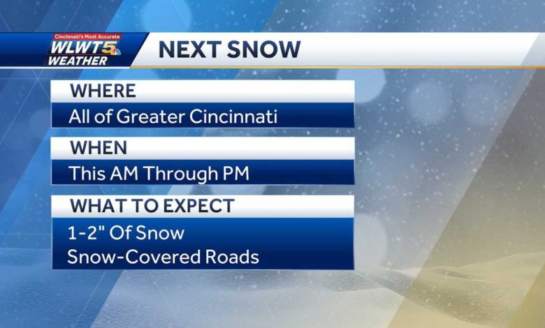
Don't put that winter gear away just yet!We are tracking more cold Monday, although temperatures will be more reasonable, and some minor snow accumulation.SEE LATEST CLOSINGS HERE // SEE WEATHER ALERTS HEREA weakening clipper system races in from the northwest with snow, which is expected to begin after 8 a.m. With the ground as cold as it is, we'll have to prepare for some more snow accumulation and times of slick travel.Medium to high travel impacts are expected Monday, as anywhere from 0-2" of snow stacks up.Highs will reach the low and mid-20s, with snow ending by Monday night.Our lows fall to around 10-15 degrees by Tuesday morning under mostly cloudy skies. Tuesday will be cold as sunshine returns, with highs around 30-33 degrees.Get ready for a big thaw to begin on Wednesday! Highs get very close to 60 degrees by Friday but, unfortunately, wet weather will also return in time for New Year's Eve celebrations.While not a washout, it looks damp for any of those weekend celebrations. You won't need a heavy jacket if you are out and about over the weekend.
Don't put that winter gear away just yet!
We are tracking more cold Monday, although temperatures will be more reasonable, and some minor snow accumulation.
SEE LATEST CLOSINGS HERE // SEE WEATHER ALERTS HERE
A weakening clipper system races in from the northwest with snow, which is expected to begin after 8 a.m.
With the ground as cold as it is, we'll have to prepare for some more snow accumulation and times of slick travel.
Medium to high travel impacts are expected Monday, as anywhere from 0-2" of snow stacks up.
Highs will reach the low and mid-20s, with snow ending by Monday night.
Our lows fall to around 10-15 degrees by Tuesday morning under mostly cloudy skies. Tuesday will be cold as sunshine returns, with highs around 30-33 degrees.
Get ready for a big thaw to begin on Wednesday! Highs get very close to 60 degrees by Friday but, unfortunately, wet weather will also return in time for New Year's Eve celebrations.
While not a washout, it looks damp for any of those weekend celebrations.
You won't need a heavy jacket if you are out and about over the weekend.
Source link