Cincinnati weather: Chance for accumulating snow returns this weekend

Updated: 6:12 PM EST Mar 8, 2023
CONGRATULATIONS. GREAT STORY THERE, BY THE WAY. FIREFIGHTERS ARE SOME GREAT COOKS. PEPPER CHILI, PLEASE. COOKING WHEN YOU GO TO VISIT THEM AND THEY’RE ALWAYS OFFERING UP FOOD. WELL, THEY’RE INTENSE BECAUSE YOU’RE 24 ON AND THEN 48. ALL RIGHT. OR WHEREVER THE OTHER WAY AROUND. I DON’T KNOW. BUT EITHER WAY, IT’S A LOT OF TIME TO COOK AND A LOT OF TIME WORKING. YEAH. SO GREAT JOB. CONGRATULATIONS, GUYS. ALL RIGHT, LET’S TALK ABOUT THIS WEATHER OUT THERE TONIGHT. CHILLY OUT. I DID NOT MEAN TO DO THAT. IT IS GOING TO BE CHILLY OUT TONIGHT. CHILLY NIGHT. A GREAT NIGHT FOR A CHILLY SOUP. ANYTHING WARM? RIGHT, BECAUSE WE DO GOT ANOTHER COLD MARCH EVENING COMING UP FOR SURE. BORROWING SOMEONE ELSE’S LINE, IT’S STARTING TO RUB OFF JUST. I KNOW. LET’S TALK ABOUT IMPROVING AHEAD HERE. WE’VE GOT SHOWERS COMING OUR WAY TOMORROW NIGHT. WE’VE GOT SOME CHILLY SHOWERS MOVING IN HERE THURSDAY NIGHT INTO EARLY FRIDAY. FOLLOWED BY THE CHANCE BY WHAT LOOKS TO BE INCREASINGLY LIKELY THAT WE HAVE AT LEAST ACCUMULATING SNOW OVER THE WEEKEND. HOW MUCH IS STILL UP IN THE AIR? BUT I THINK ODDS ARE BETTER THAN NOT WE END UP WITH A LITTLE SNOW, ESPECIALLY IN THE GRASS THIS WEEKEND. WE’LL TALK MORE ABOUT THAT HERE IN JUST A MOMENT. OUTSIDE RIGHT NOW, MARCH SUN DID ITS THING TODAY WITH TEMPERATURES PUSHED US UP TO 50 DEGREES. THAT, OF COURSE, IS AFTER WE STARTED THE MORNING RIGHT AROUND THAT FREEZING MARK. RIGHT NOW, IT’S 46 IN WILMINGTON, BLAND, CHESTER, MOUNT, AUBURN COMING IN AT 46, IT’S LOVELAND AND SPRING BALL AT 49, 50 AND HAMILTON AND HARRISON 50 AROUND DALE HIGH. SO MOST OF US ARE WITHIN YOU KNOW ABOUT A DEGREE OR TWO OF THAT 50 DEGREE MARK HERE THIS EVENING. WE STARTED OUT WITH SOME CLOUDS. THE CLOUDS GOT OUT OF HERE IN A HURRY. NOW, THE WEATHER SYSTEM WE’RE WATCHING FOR TOMORROW IS OUT HERE TO THE WEST. BUT HIGH PRESSURE KIND OF KEEPING IT AT BAY FOR NOW. YOU SEE WHAT HAPPENED WITH THAT RAIN THAT WAS OVER IN ILLINOIS. THAT WILL CHANGE TOMORROW. HIGH PRESSURE WILL BREAK DOWN THIS SYSTEM WILL BE ABLE TO ADVANCE ITS WAY OFF TOWARDS THE EAST. FOR TONIGHT, THOUGH, IT’S QUIET. IT’S COLD UNDERNEATH, PARTLY CLOUDY TO MOSTLY CLEAR SKIES. TEMPERATURES WILL GET DOWN TO AROUND THE FREEZING MARK, MAYBE EVEN SNEAK INTO THE TWENTIES OUT IN SOME OF THE BURBS. SO, YEAH, A FREEZE CERTAINLY EXPECTED OVERNIGHT TONIGHT. LET ME SHOW YOU FUTURE CASTING HERE. SO NOTHING TO WORRY ABOUT WHEN YOU WAKE UP TOMORROW MORNING. IN FACT, I THINK YOUR THURSDAY SHOULDN’T BE FAIRLY DECENT FOR MARCH. WE’LL HAVE SUNSHINE EARLY. CLOUDS WILL FILL IN THROUGHOUT THE DAY. WE’RE STILL HEADED FOR HIGHS IN THE LOW TO MID 50, SO THAT SHOULD FEEL PRETTY NICE RIGHT NOW AFTER EIGHT OR 9:00 TOMORROW NIGHT. YOU SEE IT RIGHT HERE. HERE COMES RAIN. IT WILL OVER SPREAD THE AREA DURING DINNERTIME. NOT PARTICULARLY HEAVY, BUT IT’LL MAKE IT KIND OF YUCKY OUT, ESPECIALLY WITH THE CHILLY TEMPERATURES THAT WILL BE IN PLACE. AND FRIDAYS JUST GOING TO BE KIND OF DREARY AND GLOOMY WITH ON AND OFF LITTLE MYSTERY OR MAYBE OCCASIONALLY A FEW SHOWERS OUT THERE AS WE START THE WEEKEND WITH CLOUDS. SATURDAY, THOUGH, IS THE BETTER OF THE TWO DAYS. OVER THE WEEKEND BECAUSE SATURDAY WILL BE IN BETWEEN SYSTEMS. SUNDAY’S WEATHER SYSTEM LOOKING MESSY RIGHT NOW. I THINK IT’S A MIX OF RAIN AND SNOW WITH THE GREATER LIKELIHOOD OF RAIN AS YOU HAD FARTHER SOUTH OF THE RIVER. BUT THE TREND HAS BEEN FOR AT LEAST A LIGHTER ACCUMULATION, ESPECIALLY IN THE GRASSY AREAS WE’RE GETTING TO THAT TIME OF THE YEAR WHERE IT’S REALLY HARD TO GET ANYTHING. THE STICK ON THE ROADS. BUT WE COULD PICK UP A COUPLE OF SLUSHY INCHES IN THE GRASS ON SUNDAY. SO COLD TONIGHT. FREEZE IN 32 TOMORROW. A NICE DAY WITH RAIN MOVING IN AFTER EIGHT. WE SHOULD TAP OUT IN THE LOW TO MID 50. SO OVERALL, NOT A BAD DAY. YOU WON’T NEED THE UMBRELLA DURING THE DAY. SO I THINK THE COMMUTES FINE. GETTING TO AND FROM SCHOOL AND WORK. YOU SHOULD BE FINE. HERE’S YOUR SEVEN DAY FORECAST. THIS DOES NOT LOOK LIKE THE MIDDLE OF MARCH, FOLKS. WHERE WAS THIS SEVEN DAY IN FEBRUARY WHEN WE HAD SEVENTIES ALL OVER IT? THIS IS CERTAINLY LOOKING MORE LIKE FEBRUARY SHOULD HAVE FOR US. NOTICE OUR NORMAL HIGH IS 50. JUST ABOUT EVERY TEMPERATURE ON THERE IS WELL BELOW NORMAL FOR THIS TIME OF THE YEAR. AND DON’T FORGET WE SPRING FORWARD IN OUR SATURDAY NIGHT, ALTHOUGH YOU MIGHT NOT WANT TO GET UP EXTRA EARLY ON SUNDAY WITH THAT KIND OF WINTRY WEA
Cincinnati weather: Chance for accumulating snow returns this weekend
Updated: 6:12 PM EST Mar 8, 2023
Hopefully you didn't get too used to the warm weather! Temperatures are slipping as the weekend nears and there's even the chance to see the first snow in a month as we head into next week. Clouds are clearing a bit now and temperatures stay in the 40s this evening. We drop to the upper 20s overnight as clouds clear again. Feels like temperatures will be in the 20s.Thursday brings partly cloudy skies with near 50 for highs. Rain rolls back in after 8 p.m. on Thursday evening and continues into Friday. Plan on off and on light showers through the day. This is a cold front that brings in even cooler air for the weekend.It will be even colder this weekend with highs in the low to mid 40s. Winter isn't over yet! Sunday is likely to bring us more snow than February ever did. A mix of rain and snow is expected. While south of the Ohio River is most likely to be a cold rain, north of the river has the better potential for snow showers. Accumulations are likely. A few flurries may linger into Monday, too.
Hopefully you didn't get too used to the warm weather!
Temperatures are slipping as the weekend nears and there's even the chance to see the first snow in a month as we head into next week.
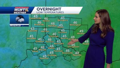
Clouds are clearing a bit now and temperatures stay in the 40s this evening. We drop to the upper 20s overnight as clouds clear again. Feels like temperatures will be in the 20s.
Thursday brings partly cloudy skies with near 50 for highs. Rain rolls back in after 8 p.m. on Thursday evening and continues into Friday.
Plan on off and on light showers through the day. This is a cold front that brings in even cooler air for the weekend.
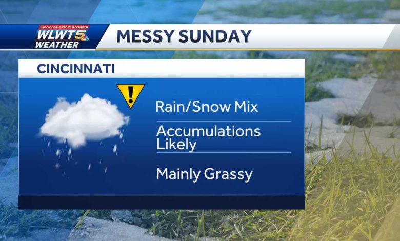
It will be even colder this weekend with highs in the low to mid 40s. Winter isn't over yet! Sunday is likely to bring us more snow than February ever did. A mix of rain and snow is expected. While south of the Ohio River is most likely to be a cold rain, north of the river has the better potential for snow showers. Accumulations are likely. A few flurries may linger into Monday, too.
Source link