LIST: Schools, businesses closing due to major winter storm

Updated: 12:39 AM EST Feb 4, 2022
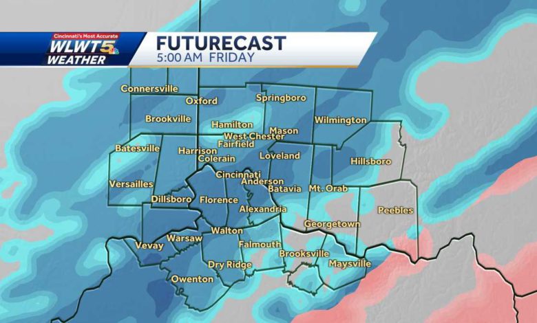
AND WE ARE HEADING INTO PHASE TWO OF THE STORM WHICH WILL BE LITERGH SNOW TO THE OVERNIGHT, FLUFFY FLAKES THAT WILL PILE OUT. I THINK THERE IS A GOOD CHANCE FOR ACCULUMATION OF REAL SNOW. WE HAVE NOT SEEN A LOT OF WHAT I CAN DO REAL SNOW THIS EVENING. IT HAS MOSTLY BEEN ALL ICE AND SLEET AROUND THE AREA. UNLESS YOU ARE NEARER SPRINGBORO, NORTH OF MIDDLETOWN AND UP THROUGH FAYETTE UNION, FRANKLIN COUNTY, OXFD,OR BROKE THOUGH, LIBERTY, CONNERSVILLE, UYO WERE REALLY ETH ONLY ONES WHO SAW ACCUMULATING SNOW OUT OF THE SYSTEM. LIGHT SNOW BEGINNING TO REDEVELOP ACROSS THE AREA. KARIN JOHNSON IS RHTIG THERE IN DEERFIELD TOWNSHIP. MESO SNOW. WE SEE LIGHT SNOW FILLING BACK IN RIGHT DOWN THE1 7 AND 75 CORRIDOR THROUGH THE CITY. SOME STEADY FLAKES. TO OUR EAST, JUST AN INCREDIBLE ICE STORM WITH WIDESPREAD POWER OUTAGES ANDRE TES DOWNED FROM ISTH EYES EARLIER TODAY. WE ARE BEGINNING TO MAKE THAT TRANSITION TO SOLID PRECIPITATION MEANING INSTEAD OF RAIN, MORE TOWARDS SLEET AND EVEN OVER TOWARDS SNOW. TH IISS PRIMARILY SLEET TOWARDS BR OOKSVILLE BUT ONCE YOU REACH THE 75 CORRIDOR, IT DOES BEGIN TO CHANGE OVER TO SNOW PRETTY QUICKLY. AT FIRST GLANCE, YOU SAY WE ARE DONE WITH THE SNOW FOR THE NIGHT. THAT IS NOT THE CA.SE THIS AREA WILL LIKELY FILL IN WITH SOME SNOW OVER THE NEXT SEVERAL HOURS AND LOOK HOW FAR ISTH EXTENDS. THERE IS SNOW FLYING TONIGHT ALL THE WAY BACK NEAR OKLAHOMA CITY SO ALL OF THIS HAS TO PULL ITS WAY THROUGH OVERNIGHT TONIGHT AND THUGROH THE FIRST PART OF YOUR DAY ON FRIDAY SO THAT MEANS BASICALLY WE ARE PROBABLY GOING TO SEE THE SNOW FILLED BACK IN WITH ONE TO THREE INCHES WE HAVE BEEN EXPECTING SO HERE IS WHAT HAPPENED TODAY. IF YOU WERE NEAR BROOKSVILLE, CONNERSVILLE, THAT COLUMOFN AIR NEAR THE ATMOSPHERE, ALL BELOW FREEZING. YOU HAD SNOW. THE BULK OF US SAT RIGHT HERE. WHERE YOU GO AUP COUEPL OF THOUSAND FEET, TEMPERATURES WERE ABOVE FREEZING. BASICALLY, WE DEALT WITH SLEET AND THAT ROBBED US OF ALL THE OWSN ALONG THE I-7CO1 RRIDOR FOR THE MOST PART AND ONCE HE GOT FURTHER SOUTH OR HOW WE STARTED THE DAY WITH THING RAIN, MORE OF THE ATMOSPHEREEL WL ABOVE AND THAT IS BASICALLY THE SETUP FOR TODAY. HERE’S WHAT WE HAD LEFT OVERALL. THINGS PLAYED OUT PUTTING MUCH AS EXPECTED. SIGNIFICANT ICE TO OUR STHOU AND THEN IN BETWEEN, A GOOD OLD-FASHIONED SETLE STORM AND WE WILL PROBABLY THROW ONE TO THREE INCHES OF SNOW ON THAT OVERNIGHT. HERE IS A LOOK AT THE ICE TOTALS. THREE INCHES OF ICE. ONCE THAT SETTLES, AND AS TEMPERATURES DROP INTOHE T TEENS AND SINGLE DIGITS, THAT WILL BE AWLLFUY HARD TO GET THAT OFF OF THOSE ROADS. THE OTHER BIG STORY, THE WIND CHILLS. WE ARE ALL IN THE LOW 20’S AND WE WILL BE IN THE TEENS BY THE TIME YOU WAKE UP IN THE MORNING AND WE HAVE GOT BITTER CDOL SETTLING IN. SINGLE WIND CHILLS OVERNIGHT EXPECTED. TOMORROW, WIND CHILLS ONLY IN THE TEENS THROUGHOUT THE DAY AND THEN TOMORROW NIGHT, WE COULD GET CLOSE TO ZERO OR BELOW WITH WIND CHILLS GETTING AWFULLY CLOSE THERE. FIVE TO 10 BELOW MAYBE, NEAR DANGEROUS THRESHOLDS. HERE IS FUTURECAST. HERE IS A LITTLE BIT OF A LLUL IN THE SNOW. WATCH WHAT HAPPENS TOWARDS MORNING. LOOK HOW THIS FLAIRS BACK UP AGAIN. ROADS WILL REMAIN A MESS THROUGH THE NIGHT. THE SNOW SHOULD SHUT OFF BEFORE NOON TOMORROW AND THEN WE WILL GO INTO THE DEEREP AD. ICY ROADS REMNAI OVERNIGHT. 18 WITH SOME SNOW. SLICK ROADS. I DON’T THINK ROADS REALLY IMPROVE MUCH, TO BE HONEST WITH YOU, BEFORE SATURD.AY THEY MIGHT GET A LITTLE BIT BETTER WITH ROAD CREWS TOMORROW BUT I WLIL TELL YOU WHAT, THAT SLEET CAN BE HARD TO MOVE ONCE IT IS SETTLED IN. MAYBE EVEN BELOW ZERO BY SATURDAY MORNING AND THEN WE WILL FINALLY
LIST: Schools, businesses closing due to major winter storm
Updated: 12:39 AM EST Feb 4, 2022
Many schools and businesses are announcing closures for Friday as a winter storm swept through the Cincinnati area.SEE THE LATEST CLOSINGS HERECincinnati Public Schools will be closed Friday due to the winter weather and many others are following suit. Significant impacts from a winter storm are expected through Friday morning. Travel is strongly discouraged now into Friday morning. LIVE RADAR // LATEST WEATHER ALERTS A winter storm warning for the entire WLWT viewing area is in effect through Friday morning. An ice storm warning is also in effect for southern communities through Friday morning.Heavy sleet and freezing rain will slowly transition to snow through the night and into Friday morning. This is when we will see the most impactful snowfall accumulations on top of the one to three inches of sleet we have seen.There will be snowfall accumulation of one to three inches for much of the Tri-State with four to six inches of snow total in our far northwest areas Oxford-Brookville and north.Travel will be very difficult at times if not impossible across most of our area. Areas that are seeing freezing rain will continue to experience a damaging ice storm with up to a half-inch and possibly more.Widespread power outages will become likely in those areas as gusty north winds increase. Temperatures will drop into the teens, with wind chills around 0 by morning.Bitter cold will follow for Friday and the start of the weekend before thawing out Sunday.We will remain below freezing until Saturday afternoon, so roads will likely remain very tricky even through Saturday morning. Lows Friday night will be near zero and below. Highs Saturday only in the mid-20s, then mid/upper-30s Sunday.
Many schools and businesses are announcing closures for Friday as a winter storm swept through the Cincinnati area.
SEE THE LATEST CLOSINGS HERE
Cincinnati Public Schools will be closed Friday due to the winter weather and many others are following suit.
Significant impacts from a winter storm are expected through Friday morning. Travel is strongly discouraged now into Friday morning.
LIVE RADAR // LATEST WEATHER ALERTS
A winter storm warning for the entire WLWT viewing area is in effect through Friday morning. An ice storm warning is also in effect for southern communities through Friday morning.
Heavy sleet and freezing rain will slowly transition to snow through the night and into Friday morning. This is when we will see the most impactful snowfall accumulations on top of the one to three inches of sleet we have seen.
There will be snowfall accumulation of one to three inches for much of the Tri-State with four to six inches of snow total in our far northwest areas Oxford-Brookville and north.
Travel will be very difficult at times if not impossible across most of our area. Areas that are seeing freezing rain will continue to experience a damaging ice storm with up to a half-inch and possibly more.
Widespread power outages will become likely in those areas as gusty north winds increase. Temperatures will drop into the teens, with wind chills around 0 by morning.
Bitter cold will follow for Friday and the start of the weekend before thawing out Sunday.
We will remain below freezing until Saturday afternoon, so roads will likely remain very tricky even through Saturday morning. Lows Friday night will be near zero and below. Highs Saturday only in the mid-20s, then mid/upper-30s Sunday.
Source link