Major winter storm moves in: Freezing rain, sleet, snow to create significant impacts
Yeah, you know, we knew this winter storm was going to throw all modes of winter weather at us and true Cincinnati style, we get all of them in the morning, right? We started out with rain, then freezing rain now sleet and eventually we will see some snow but for the next couple of hours plan on being locked in with freezing rain and sleet as our kind of dominant weather types. Because I just checked in the National Weather service actually sent out there, set up their balloon this morning and it showed there's some warmer air kind of creeping in through our upper areas of our atmosphere. What that's gonna do is keep us from transitioning to snow. We're gonna stay locked in with sleet or freezing rain for the next several hours in through the rest of the morning into the afternoon as we were expecting right this afternoon, pretty sleepy before we end up transitioning to some snow. And that might not happen for some of us till tomorrow morning. So even though the radar is trying to paint Fate and Union counties blue indicating snow, it's been some sleep for them this morning. They actually were the first ones to have icy roads early and then some sleep that coded some of those cooler surfaces part of me and then in through portions of franklin County, you've got sleep coming down pretty good through much of Butler County, Middletown had accumulating sleep this morning, Springboro, same thing head down I 75 you're running into sleet and some freezing rain mixed in the pink indicating freezing rain, which is, you know, the rain that falls on stuff that's colder, right? So things that are below freezing, so accumulating on the trees, the power lines, we're getting some very pretty pictures in. But again, it's not pretty when you're driving out and especially if we're gonna see this persisting for the next several hours and you start to see more of that ice accumulating on surfaces. Eventually it can kind of sag down those tree limbs they may snap. Also the potential for power lines to be impacted by any sort of repeated rounds or sustained periods of freezing rain, which is what we're seeing right now, just a little bit to the south and through portions of northern Kentucky, freezing rain continues through all of Boone County coming down pretty good southern, just south of Florence into Independence. Spiner and kenton. We'll go east here and head out into portions of clinton and highland County's. You could see freezing rain, they're probably a little bit of sleet mixed in now, but looking at freezing rain falling in Hillsborough new market. So any of the more rural routes that have had no pre treatment, remember it was raining all day yesterday in through the overnight hours, so no pre treatment was done. So there may be some very slick rural routes here, especially in three areas of highland County and Brown and Adams counties the system as a whole is very large. But you'll notice the motion is I put a kind of our long time lapse on this check out what's kind of trailing in our direction. Right? That's that freezing rain and sleet versus the snow. That's kind of focus back toward indie that's moving in the direction of northeast Ohio. This system as a whole will shift east eventually, but we're basically hitting pause here for the next couple of hours and keeping with this wintry mix of sleet and freezing rain right now, temperature wise, right at freezing in Cincinnati at CVG To the North where we're seeing more pronounced heavy sleet is up in Butler County and Warren County where we're at 30° in Mason and Hambleton Down to 29 in Harrison and still holding on to some towns to the south that are above freezing for the morning hours. Again, this major winter storm is going to impact us, not just today, but tonight and the first part of the day tomorrow and really tomorrow is when you may wake up and see the fresh coat of snow today, it's accumulating sleet and some freezing rain with accumulating ice. So the roads will continue to deteriorate as we go through the morning, Our future Cast shows us kind of locked in for the next several hours with that mix of freezing rain and sleet, especially some heavier sleeves, that colder air finally starts to creep in this afternoon that deep blue that you're seeing here on future cast usually wants to show that a snow But we're with that sounding of our atmosphere. I think this is gonna be some heavy sleet as we get into the afternoon hours and eventually this evening as the colder air finally takes over, we'll switch over to snow and you can see that little burst of accumulating fluffy snow that will have tomorrow morning with that much colder air in place will be down in the teens when that snow is flying on friday morning. That also does come coupled with winds 20 to 30 miles an hour. So if you have some decent ice accumulation on the trees and power lines, they're already heavy, they're hanging down and you have a 30 mile an hour, wind gusts that could cause more of those to snap and potentially cause more power outages as well noticed. By late morning, tomorrow we're on the backside of the system and the very cold air arrives after that there will be plenty of towns friday night into saturday morning that dip below zero. So the biggest issue for much of our of our area will be the messy mix of sleet and freezing rain to the south though. That's where the heavy icing concerns are the greatest for us where maybe up to a half inch of ice is going to be a possibility. Alright, let's head over to Katie Donovan. I know she's kept dry and all the roads going through the morning. What's going on right now. Mm hmm.
Major winter storm moves in: Freezing rain, sleet, snow to create significant impacts
A major winter storm is moving into the Cincinnati area and is expected to create significant impacts on roadways.LIVE RADAR // LATEST WEATHER ALERTS // CLOSINGS Significant impacts from a winter storm are expected Thursday through Friday. Travel is strongly discouraged after mid-morning Thursday.A winter storm warning for the entire WLWT viewing area is in effect through Friday morning. Radar will show a colorful picture to start the day Thursday, but what actually makes it to the ground initially will just be plain old rain. It will take some time for freezing rain to really stick to the roads as those pavement temperatures are above freezing. Don't let your guard down if you have a smooth pre-dawn commute, ice will begin to really stick to the pavement around sunrise. Spotty slick travel will be possible for the early morning drive (mainly on those bridges and overpasses), but worse road conditions are expected by mid-morning hours and into lunchtime.We'll likely see a time of heavy sleet as we push into the lunch hour and the afternoon. This will continue to deteriorate the roads across the region. Winds will be sustained to around 20 mph at times Thursday. This will create reduced visibility and sleet/freezing rain that comes down sideways.A wintry mix will begin to transition to snow through the I-275 loop and points west through the late afternoon and early evening Thursday. This is thanks to the colder air working in. Everyone sees snow through the overnight as temperatures drop to the teens.Snow continues through Friday morning. As of right now, the greatest accumulation of snow will be northwest of the 275 loop (north of 74 in SE Indiana and northernmost Butler County) with 4 to 6 inches or more possible. In and around the 275 loop and much of Greater Cincinnati will see more sleet than ice accumulation, then snow. Snow will end early Friday morning with accumulations around 1 to 3 inches. To the south and east of the I-71/75 split, the freezing rain lingers longer. This means the ice accumulation there could be 0.5 inches which causes power issues and roads turn to ice rinks. The snow totals there will be the lowest around an inch or so.Bitter cold will follow for Friday and the start of the weekend before thawing out Sunday.
A major winter storm is moving into the Cincinnati area and is expected to create significant impacts on roadways.
LIVE RADAR // LATEST WEATHER ALERTS // CLOSINGS
Significant impacts from a winter storm are expected Thursday through Friday. Travel is strongly discouraged after mid-morning Thursday.
A winter storm warning for the entire WLWT viewing area is in effect through Friday morning.
Radar will show a colorful picture to start the day Thursday, but what actually makes it to the ground initially will just be plain old rain. It will take some time for freezing rain to really stick to the roads as those pavement temperatures are above freezing.
Don't let your guard down if you have a smooth pre-dawn commute, ice will begin to really stick to the pavement around sunrise. Spotty slick travel will be possible for the early morning drive (mainly on those bridges and overpasses), but worse road conditions are expected by mid-morning hours and into lunchtime.
We'll likely see a time of heavy sleet as we push into the lunch hour and the afternoon. This will continue to deteriorate the roads across the region. Winds will be sustained to around 20 mph at times Thursday. This will create reduced visibility and sleet/freezing rain that comes down sideways.
A wintry mix will begin to transition to snow through the I-275 loop and points west through the late afternoon and early evening Thursday. This is thanks to the colder air working in. Everyone sees snow through the overnight as temperatures drop to the teens.
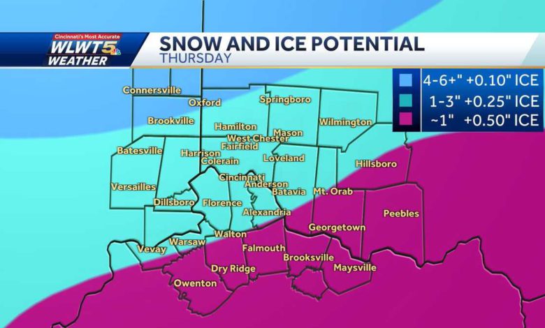
Snow continues through Friday morning. As of right now, the greatest accumulation of snow will be northwest of the 275 loop (north of 74 in SE Indiana and northernmost Butler County) with 4 to 6 inches or more possible.
In and around the 275 loop and much of Greater Cincinnati will see more sleet than ice accumulation, then snow.
Snow will end early Friday morning with accumulations around 1 to 3 inches.
To the south and east of the I-71/75 split, the freezing rain lingers longer. This means the ice accumulation there could be 0.5 inches which causes power issues and roads turn to ice rinks. The snow totals there will be the lowest around an inch or so.
Bitter cold will follow for Friday and the start of the weekend before thawing out Sunday.
Source link


