
As the snow melts, another round of wintry weather moves in Wednesday.LIVE RADAR//LATEST WEATHER ALERTS//CLOSINGSClouds are moving in Wednesday morning, but winds from the south are driving temperatures up into the upper 40s by the early afternoon. At the same time, an arctic front will approach Greater Cincinnati Wednesday. It still looks like this system is focused mainly south of the Ohio River. Towns could see a little rain by mid-afternoon followed by a switch to some snow during Wednesday evening's commute. A Winter Weather Advisory starts Wednesday evening mainly for areas that got hit hardest on Sunday night, like Dry Ridge, Owenton, Maysville, Peebles and Georgetown. These areas could see 1-3 inches of accumulation this evening and night. Temperatures drop below freezing after 8 p.m. so the late night is when the snow will stick and there's the potential for slick travel overnight into early Thursday morning. Remember, when it rains first then snows the road crews can't pre-treat because the rain washes off the salt and brine. As far as snow totals go, much of Greater Cincinnati in and around the I-275 loop see a dusting up to 1 inch. Southeast of Cincinnati and south of the I-71/75 split is where the totals of 1 to 2 inches will be common and some spots of 3 inches are possible. And heads up if you are traveling to Nashville Thursday, don't get too early of a start. Let their roads improve, too. The winter weather advisory in central Kentucky lasts through 8 a.m.
As the snow melts, another round of wintry weather moves in Wednesday.
LIVE RADAR//LATEST WEATHER ALERTS//CLOSINGS
Clouds are moving in Wednesday morning, but winds from the south are driving temperatures up into the upper 40s by the early afternoon.
At the same time, an arctic front will approach Greater Cincinnati Wednesday. It still looks like this system is focused mainly south of the Ohio River.
Towns could see a little rain by mid-afternoon followed by a switch to some snow during Wednesday evening's commute.
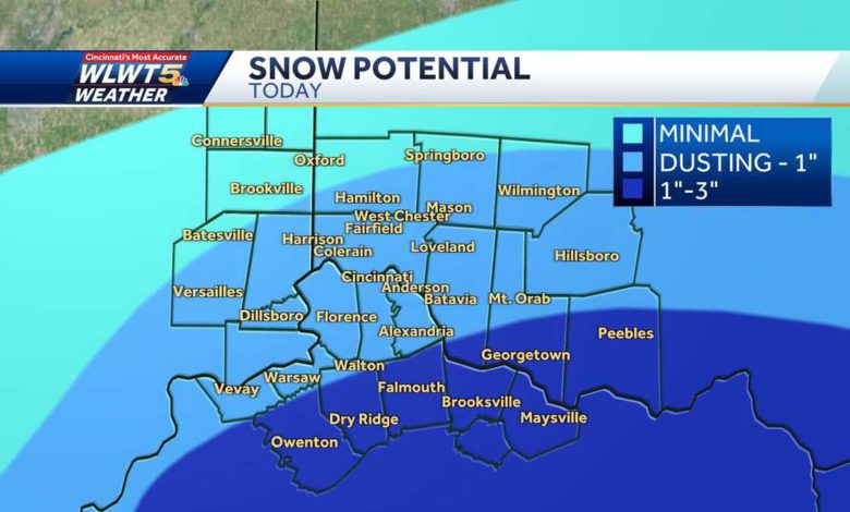
A Winter Weather Advisory starts Wednesday evening mainly for areas that got hit hardest on Sunday night, like Dry Ridge, Owenton, Maysville, Peebles and Georgetown. These areas could see 1-3 inches of accumulation this evening and night.
Temperatures drop below freezing after 8 p.m. so the late night is when the snow will stick and there's the potential for slick travel overnight into early Thursday morning.
Remember, when it rains first then snows the road crews can't pre-treat because the rain washes off the salt and brine.
As far as snow totals go, much of Greater Cincinnati in and around the I-275 loop see a dusting up to 1 inch. Southeast of Cincinnati and south of the I-71/75 split is where the totals of 1 to 2 inches will be common and some spots of 3 inches are possible.
And heads up if you are traveling to Nashville Thursday, don't get too early of a start. Let their roads improve, too. The winter weather advisory in central Kentucky lasts through 8 a.m.
Source link


