Cincinnati will see frigid temperatures, followed by a chance for accumulating snow. Colder air is here for the weekend.Friday starts a good 10 degrees cooler than Thursday with highs in the mid-to-upper 30s. It will feel like the low 30s Friday afternoon.LIVE RADAR // LATEST WEATHER ALERTSFrigid temperatures will stick around Saturday for the Bengals game. Temperatures will be in the mid-20s as tailgates get started, and wind chills will be in the teens. By noon, temperatures are closer to 30 degrees with wind chills near 20 degrees. Kickoff temperatures will be around 31 degrees to break the 31-year streak without a playoff win.After that, we're watching for a chance for snow to close out this weekend. This system will dive south through Iowa Friday, then join up with a lot more moisture from the Gulf and head toward the East Coast. It hits more than 30 states in the next few days.The latest track trends at least some of that snow up into our area on Sunday. Locations to the southeast of the Interstate 71 corridor would have the best chance for some decent snow. As you head to the further south and east in areas of Adams, Brown, Bracken, Mason, Robertson, those areas have the best bet for decent snowfall.However, as it is so far out, a lot can change before Sunday. Stay tuned!
Cincinnati will see frigid temperatures, followed by a chance for accumulating snow.
Colder air is here for the weekend.
Friday starts a good 10 degrees cooler than Thursday with highs in the mid-to-upper 30s.
It will feel like the low 30s Friday afternoon.
LIVE RADAR // LATEST WEATHER ALERTS
Frigid temperatures will stick around Saturday for the Bengals game.
Temperatures will be in the mid-20s as tailgates get started, and wind chills will be in the teens. By noon, temperatures are closer to 30 degrees with wind chills near 20 degrees. Kickoff temperatures will be around 31 degrees to break the 31-year streak without a playoff win.
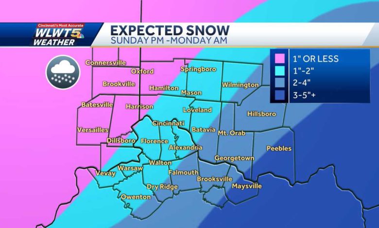
After that, we're watching for a chance for snow to close out this weekend. This system will dive south through Iowa Friday, then join up with a lot more moisture from the Gulf and head toward the East Coast.
It hits more than 30 states in the next few days.
The latest track trends at least some of that snow up into our area on Sunday. Locations to the southeast of the Interstate 71 corridor would have the best chance for some decent snow.
As you head to the further south and east in areas of Adams, Brown, Bracken, Mason, Robertson, those areas have the best bet for decent snowfall.
However, as it is so far out, a lot can change before Sunday. Stay tuned!
Source link