
The first snow of the year is arriving in Cincinnati Thursday.An arctic cold front arrives Wednesday. This front won't bring us any rain or snow, just strong winds and a push of cold air. As that front passes by we'll see temperatures tumble quickly for the afternoon. By the evening rush, temperatures are in the low 30s and with the winds, it will feel like the teens.As our temperatures crash, a storm center will be forming down in Louisiana/Mississippi. That will be our snowmaker for Thursday as it moves toward the Appalachian Mountains.Some snow is expected Thursday. Where the storm center tracks will impact snow amounts. Right now, we are leaning toward a far southern track which would mean lighter amounts.Overall, northwest of Hamilton County gets an inch or less. The metro and along I-71 will pick up around an inch. Areas southeast of I-71 and south of the 71-75 split have the best chance of getting 2 inches of snow.The snow starts falling to our south Thursday around 12 p.m., arriving in Cincinnati by 3 p.m. and continues through the evening. It is expected to stick on contact, which could lead to dicey roads as soon as the afternoon. Roads are expected to be snow-covered overnight and Friday morning.Very cold air is expected Thursday night into Friday. Wind chills are going to be around zero degrees Friday morning. Temperatures weakly rebound by the weekend as rain returns Saturday night-Sunday.The Ohio River is now in action stage. The river is forecast to crest this morning at 49.5 feet, just a couple feet below flood stage. Some areas along the Ohio start being impacted at 42 feet and beyond.
The first snow of the year is arriving in Cincinnati Thursday.
An arctic cold front arrives Wednesday. This front won't bring us any rain or snow, just strong winds and a push of cold air.
As that front passes by we'll see temperatures tumble quickly for the afternoon. By the evening rush, temperatures are in the low 30s and with the winds, it will feel like the teens.
As our temperatures crash, a storm center will be forming down in Louisiana/Mississippi. That will be our snowmaker for Thursday as it moves toward the Appalachian Mountains.
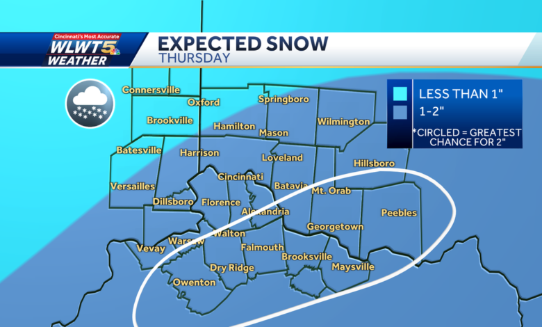
Some snow is expected Thursday. Where the storm center tracks will impact snow amounts.
Right now, we are leaning toward a far southern track which would mean lighter amounts.
Overall, northwest of Hamilton County gets an inch or less. The metro and along I-71 will pick up around an inch. Areas southeast of I-71 and south of the 71-75 split have the best chance of getting 2 inches of snow.
The snow starts falling to our south Thursday around 12 p.m., arriving in Cincinnati by 3 p.m. and continues through the evening.
It is expected to stick on contact, which could lead to dicey roads as soon as the afternoon. Roads are expected to be snow-covered overnight and Friday morning.
Very cold air is expected Thursday night into Friday. Wind chills are going to be around zero degrees Friday morning. Temperatures weakly rebound by the weekend as rain returns Saturday night-Sunday.
The Ohio River is now in action stage. The river is forecast to crest this morning at 49.5 feet, just a couple feet below flood stage. Some areas along the Ohio start being impacted at 42 feet and beyond.
Source link