Watch Biden's address live in the video player abovePresident Joe Biden is using his first joint address to Congress to declare the nation is "turning peril into possibility, crisis into opportunity," urging a $1.8 trillion investment in children, families and education that would fundamentally transform roles the government plays in American life.The prime-time speech comes on the eve of his 100th day in office. Follow along below for live updates. All times eastern9:55 p.m.Biden highlighted the major military move to pull back American troops from Afghanistan during his speech. "American leadership means ending the forever war in Afghanistan," Biden said Wednesday. "After 20 years of American valor and sacrifice, it’s time to bring our troops home."The president announced earlier this month that America's longest war would end by the fall.Biden plans to pull out all American forces — numbering 2,500 now — by this Sept. 11, the 20th anniversary of the attacks. The drawdown would begin rather than conclude by May 1, which has been the deadline for full withdrawal under a peace agreement the Trump administration reached with the Taliban last year.9:50 p.m.Pivoting to foreign policy, President Biden says he is open to competition from China, but not conflict."America will stand up to unfair trade practices that undercut American workers and industries, like subsidies for state-owned enterprises and the theft of American technologies and intellectual property," Biden said. "I also told President Xi that we will maintain a strong military presence in the Indo—Pacific just as we do with NATO in Europe – not to start conflict – but to prevent conflict."On Russia, Biden said he "made very clear to President Putin that while we don’t seek escalation, their actions have consequences. I responded in a direct and proportionate way to Russia’s interference in our elections and cyberattacks on our government and businesses — and they did both of those things and I did respond."9:35 p.m.Biden outlined details of his American Families Plan. The plan focuses on so-called human infrastructure — child care, health care, education and other ways to support households.Biden's proposal calls for universal preschool, two years of free community college, $225 billion for child care and monthly payments of at least $250 to parents. Biden wants to pay for it by hiking taxes on very high-income households. The president has drawn a firm red line that no household earning less than $400,000 a year will pay more in taxes.9:30 p.m.President Biden is marking his first 100 days in office by highlighting passage of the $1.9 trillion pandemic relief legislation known as the American Rescue Plan and he’s noting that his administration has provided more than 220 million COVID-19 vaccine shots.Biden says he inherited a nation in crisis and now he can report that “America is on the move again.”In his first address to Congress as president, Biden says the United States is already seeing the results of “one of the most consequential rescue packages in American history.” He’s emphasizing that the package included $1,400 checks to 85% of U.S. households. And he says more than 160 million checks are already out the door.As to the vaccine, he says it is available in nearly 40,000 pharmacies and more than 700 community health centers.Now, 90% of Americans live within 5 miles of a vaccination site, and Biden’s message is, “Go get vaccinated America.”Biden is also emphasizing that the economy is on the mend under his watch.9:25 p.m.President Biden touted his proposed infrastructure plan during his address to Congress. Here's a look at what's in it:Biden wants $2 trillion to reengineer America's infrastructure. Biden’s infrastructure projects would be financed by higher corporate taxes. The White House says the largest chunk of the proposal includes $621 billion for roads, bridges, public transit, electric vehicle charging stations and other transportation infrastructure. The spending would push the country away from internal combustion engines that the auto industry views as an increasingly antiquated technology. Another $111 billion would go to replace lead water pipes and upgrade sewers. Broadband internet would blanket the country for $100 billion. Separately, $100 billion would upgrade the power grid to deliver clean electricity. Homes would get retrofitted, schools modernized, workers trained and hospitals renovated under the plan, which also seeks to strengthen U.S. manufacturing.9:05 p.m.President Biden is introduced by House Speaker Nancy Pelosi to begin his address.Biden is marking his 100th day in office with a prime-time address to Congress and he's declaring that the United States is "turning peril into possibility."Biden is using his nationally televised speech to promote a $1.8 trillion spending package. He says it will fundamentally transform and expand government’s role in the lives of everyday Americans.If Congress approves the plan, it would provide universal preschool, two years of free community college, $225 billion for child care and monthly payments of at least $250 to parents.The president is also presenting a vision for post-pandemic life nationwide. He’s working to showcase the hundreds of millions of vaccinations and relief checks his administration has delivered, even as the coronavirus remains dangerous and deadly. The pandemic has claimed the lives of more than 574,000 Americans. 9 p.m. Vice President Kamala Harris and House Speaker Nancy Pelosi are making history as the first women to share center stage in Congress during a presidential address.Harris and Pelosi are seated behind Biden on Wednesday night for his joint address to Congress. When they greeted each other before Biden's arrival, Harris and Pelosi clasped hands before giving each other a COVID-19-friendlier elbow bump. Pelosi has sat at the rostrum in the House chamber before but always next to a male vice president: Dick Cheney, Biden and Mike Pence. Harris is the first female vice president in U.S. history.Women’s advocates have said seeing Harris and Pelosi seated together behind Biden will be a "beautiful moment." But they noted that electing a woman to sit in the Oval Office remains to be achieved, along with the addition of an equal rights amendment to the Constitution.8:55 p.m.Security is tight and the crowd is thin at the Capitol, under strict coronavirus restrictions for President Joe Biden’s address to Congress.The first address by a president to Congress is usually an electrifying evening. But this time it's a more subdued affair.A few dozen lawmakers milled about the House chamber not long before Biden's speech, and a reduced crowd of about 200 is expected. That's compared with an audience of 1,600 members of Congress, officials and guests who typically gather for the event.Face masks are mandatory in the House chamber. Place cards marked the seats, with just one or two lawmakers per row. Some are sitting high in the visitors’ galleries. No guests were invited.National Guard troops protecting the Capitol since the Jan. 6 insurrection are stationed in and around the building.
Watch Biden's address live in the video player above
President Joe Biden is using his first joint address to Congress to declare the nation is "turning peril into possibility, crisis into opportunity," urging a $1.8 trillion investment in children, families and education that would fundamentally transform roles the government plays in American life.
The prime-time speech comes on the eve of his 100th day in office.
Follow along below for live updates. All times eastern
9:55 p.m.
Biden highlighted the major military move to pull back American troops from Afghanistan during his speech.
"American leadership means ending the forever war in Afghanistan," Biden said Wednesday. "After 20 years of American valor and sacrifice, it’s time to bring our troops home."
The president announced earlier this month that America's longest war would end by the fall.
Biden plans is to pull out all American forces — numbering 2,500 now — by this Sept. 11, the 20th anniversary of the attacks. The drawdown would begin rather than conclude by May 1, which has been the deadline for full withdrawal under a peace agreement the Trump administration reached with the Taliban last year.
9:50 p.m.
Pivoting to foreign policy, President Biden says he is open to competition from China, but not conflict.
9:35 p.m.
Biden outlined details of his American Families Plan. The plan focuses on so-called human infrastructure — child care, health care, education and other ways to support households.
Biden's proposal calls for universal preschool, two years of free community college, $225 billion for child care and monthly payments of at least $250 to parents. Biden wants to pay for it by hiking taxes on very high-income households.
The president has drawn a firm red line that no household earning less than $400,000 a year will pay more in taxes.
9:30 p.m.
President Biden is marking his first 100 days in office by highlighting passage of the $1.9 trillion pandemic relief legislation known as the American Rescue Plan and he’s noting that his administration has provided more than 220 million COVID-19 vaccine shots.
Biden says he inherited a nation in crisis and now he can report that “America is on the move again.”
In his first address to Congress as president, Biden says the United States is already seeing the results of “one of the most consequential rescue packages in American history.”
He’s emphasizing that the package included $1,400 checks to 85% of U.S. households. And he says more than 160 million checks are already out the door.As to the vaccine, he says it is available in nearly 40,000 pharmacies and more than 700 community health centers.
Now, 90% of Americans live within 5 miles of a vaccination site, and Biden’s message is, “Go get vaccinated America.”
Biden is also emphasizing that the economy is on the mend under his watch.
9:25 p.m.
President Biden touted his proposed infrastructure plan during his address to Congress. Here's a look at what's in it:
Biden wants $2 trillion to reengineer America's infrastructure. Biden’s infrastructure projects would be financed by higher corporate taxes.
The White House says the largest chunk of the proposal includes $621 billion for roads, bridges, public transit, electric vehicle charging stations and other transportation infrastructure. The spending would push the country away from internal combustion engines that the auto industry views as an increasingly antiquated technology. Another $111 billion would go to replace lead water pipes and upgrade sewers.
Broadband internet would blanket the country for $100 billion. Separately, $100 billion would upgrade the power grid to deliver clean electricity. Homes would get retrofitted, schools modernized, workers trained and hospitals renovated under the plan, which also seeks to strengthen U.S. manufacturing.
9:05 p.m.
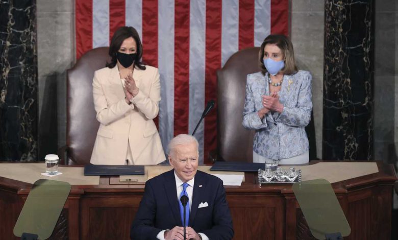
President Biden is introduced by House Speaker Nancy Pelosi to begin his address.
Biden is marking his 100th day in office with a prime-time address to Congress and he's declaring that the United States is "turning peril into possibility."
Biden is using his nationally televised speech to promote a $1.8 trillion spending package. He says it will fundamentally transform and expand government’s role in the lives of everyday Americans.
If Congress approves the plan, it would provide universal preschool, two years of free community college, $225 billion for child care and monthly payments of at least $250 to parents.
The president is also presenting a vision for post-pandemic life nationwide. He’s working to showcase the hundreds of millions of vaccinations and relief checks his administration has delivered, even as the coronavirus remains dangerous and deadly. The pandemic has claimed the lives of more than 574,000 Americans.
9 p.m.
Vice President Kamala Harris and House Speaker Nancy Pelosi are making history as the first women to share center stage in Congress during a presidential address.
Harris and Pelosi are seated behind Biden on Wednesday night for his joint address to Congress. When they greeted each other before Biden's arrival, Harris and Pelosi clasped hands before giving each other a COVID-19-friendlier elbow bump.
Pelosi has sat at the rostrum in the House chamber before but always next to a male vice president: Dick Cheney, Biden and Mike Pence. Harris is the first female vice president in U.S. history.
Women’s advocates have said seeing Harris and Pelosi seated together behind Biden will be a "beautiful moment." But they noted that electing a woman to sit in the Oval Office remains to be achieved, along with the addition of an equal rights amendment to the Constitution.
8:55 p.m.
Security is tight and the crowd is thin at the Capitol, under strict coronavirus restrictions for President Joe Biden’s address to Congress.
The first address by a president to Congress is usually an electrifying evening. But this time it's a more subdued affair.
A few dozen lawmakers milled about the House chamber not long before Biden's speech, and a reduced crowd of about 200 is expected. That's compared with an audience of 1,600 members of Congress, officials and guests who typically gather for the event.
Face masks are mandatory in the House chamber. Place cards marked the seats, with just one or two lawmakers per row. Some are sitting high in the visitors’ galleries. No guests were invited.
National Guard troops protecting the Capitol since the Jan. 6 insurrection are stationed in and around the building.
Source link


