- A tornado watch was issued for parts of Louisiana, including New Orleans.
- Storm preparations were complicated by the pandemic.
- The storm was arriving on the 16th anniversary of Hurricane Katrina's landfall.
NEW ORLEANS – Hurricane Ida roared closer to the Louisiana coastline Sunday, a Category 4 storm driving winds of 150 mph that could grow stronger before slamming onto shore later in the day.
The National Weather Service warned of life-threatening storm surge, potentially catastrophic wind damage and flooding rainfall for much of coastal Louisiana and Mississippi. Meteorologist Benjamin Schott told the USA TODAY Network that Ida could become a Category 5 hurricane before it makes landfall Sunday afternoon near New Orleans in Jefferson or Lafourche Parish.
"I’m speechless," Schott said. "I’m sick to my stomach. It’s going to be a horrible day. All of the worst things we thought the storm could do I think are about to happen."
Ida was centered about 85 miles south of New Orleans late Sunday morning, rolling to the northwest at 13 mph. A Category 5 hurricane, top of the scale, has sustained winds of 157 miles per hour.
The National Oceanic and Atmospheric Administration tracked gusts of up to 121 miles per hour on land as Ida's northern eyewall approached the coast. New Orleans is expected to see more than a foot of rain, prompting fears of street flooding. Storm surge was already causing flooding in Mississippi.
"This is a sight no one wants to see on satellite," the weather service tweeted Sunday. "Ida ... continues to approach southeastern Louisiana. This remains a serious, life-threatening situation."
The center of Ida was forecast to continue moving across the north-central Gulf of Mexico on Sunday morning and make landfall Sunday afternoon or evening. Ida is then forecast to move well inland over portions of Louisiana and western Mississippi on Monday and Monday night.
'Today is it': Louisiana, Gulf Coast brace for a hit Sunday from 'extremely dangerous' Hurricane Ida
A tornado watch was issued for parts of Louisiana, including New Orleans, as well as parts of Florida, Mississippi and Alabama, according to the National Weather Service in New Orleans. The watch runs through 7 p.m.
Ida, moving over the extremely warm waters of the Gulf, saw its top winds grow by 45 mph in five hours. The phenomenon, known as "rapid intensification," is typically defined to be a tropical cyclone intensifying by at least 35 mph in a 24-hour period, according to Colorado State University meteorologist Phil Klotzbach. That can happen when a storm encounters an extremely conducive environment such as very warm water, low vertical wind shear and high levels of mid-level moisture.
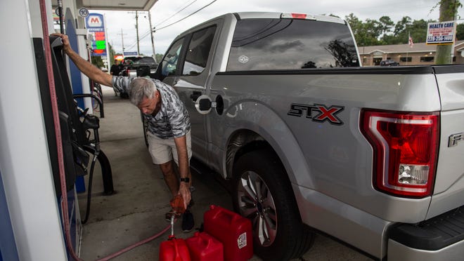
Ida intensified so swiftly that New Orleans Mayor LaToya Cantrell said there was no time to organize a mandatory evacuation. She urged the city's 390,000 residents to leave voluntarily and warned those who stayed to prepare for long power outages.
The winds were whipping in the city Sunday as the outer edge of Hurricane Ida approached. At the time, more than 15,000 were already without power in Orleans Parish, according to Entergy energy company. Entergy said 16,000 crew members were ready to assess damages and restore power as conditions allow.
"Conditions will be extremely hazardous," the city Office of Homeland Security and Emergency Preparedness tweeted. "Power lines may fall and debris could become projectiles. Get inside and stay inside."
Residents were heeding the warnings. Aside from the gusting wind, the scene was eerily quiet on the city’s empty streets. During lesser storms, cars park atop curbs or pack onto grassy medians that divide many of the roads. But ahead of Ida, few cars could be seen, a sign that many local had fled ahead of the storm.
In Terrebonne Parish, 50 miles southwest of New Orleans, Sheriff Tim Soignet said at least 60%-70% of residents had evacuated. Officers were monitoring the storm surge.
"It's currently typical South Louisiana weather, but we'll start feeling the wind bands soon," Soignet said. "We're going to continue to monitor until it's unsafe. And we'll come back out again after (the storm) to assess the damage."
The nonprofit Cajun Navy Foundation is planning to send its Cajun Navy Ground Force to Houma, La., in Terrebonne Parish, on Monday once the situation is safe, foundation founder Rob Gaudet said.
He estimated that more than 100 volunteers will descend to the area to help with cleanup and other related efforts.
“We feel an even greater sense of urgency to be prepared,” Gaudet said. “And we went, actually last night, and purchased about three more chainsaws and kits.”
Volunteers Jay Carter, of Georgia said his son texted him while he was on his way to Louisiana. His son didn't want Carter to leave.
“I basically told him that we all do this because one day if you’re ever in trouble, our kids, ourselves, then hopefully someone like Cajun Navy will come along help us as well,” Carter said.
More than 2,000 FEMA emergency personnel were deployed to Alabama, Florida, Georgia, Louisiana, Mississippi and Texas, including seven FEMA Incident Management Assistance Teams in Louisiana and Mississippi, the agency said.
Storm preparations were complicated by the pandemic. Louisiana has been overwhelmed with cases, and most hospitals were preparing to continue operating through the storm. Ochsner Health, Louisiana's largest hospital system, equipped its hospitals with power generators and boilers to ensure the availability of hot water and power.
Gov. John Bel Edwards said shelters would operate with reduced capacities to reflect the "realities of COVID.” Immigration and Customs Enforcement and the Customs and Border Protection agencies said they would not conduct immigration enforcement at locations where disaster and emergency relief related was being provided.
The storm was arriving on the 16th anniversary of Hurricane Katrina's landfall as a Category 3 storm. Most of the city flooded, almost 2,000 people died, and federal officials estimated the damage at $125 billion.
On Saturday, more than 90% of the Gulf of Mexico’s oil production was shut down as Ida churned through the western Gulf of Mexico. About 85% of the Gulf’s natural gas production had also been halted, according to the federal Bureau of Safety and Environmental Enforcement.
Workers had been evacuated from at least half of the 560 production platforms in the Gulf, according to the bureau.
Here's what you need to know about flash floods: 'They can occur in all 50 states'
Five named systems have reached the U.S. this year, but Ida was poised to be the first to make landfall at hurricane strength.
A hurricane warning was issued for most of the Louisiana coast from Intracoastal City to the mouth of the Pearl River, including the New Orleans metropolitan area. A tropical storm warning was extended to the Alabama-Florida border.
A state of emergency was issued across coastal and western counties in Alabama, and in the entire state of Mississippi on Saturday afternoon.
Bacon reported from Arlington, Va. Contributing: Susan Miller and Doyle Rice, USA TODAY; William Potter, The (Lafayette, La.) Daily Advertiser; Emily Enfinger, Keith Magill and Kezia Setyawan, The (Houma, La.) Courier; Greg Hilburn, the (Monroe, La.) News Star

Source link


