
A winter storm is targeting Cincinnati, expected to deliver at least six inches of snow – and perhaps much more. The storm is just now making its way over land, currently over Seattle. It’s expected to make its way south, picking up Gulf moisture, before walloping the Cincinnati region late Sunday night and through Tuesday morning. LIVE RADAR // CLOSURES & DELAYS // WEATHER ALERTSAs it still has around 2,500 miles to travel, a lot is still undetermined. Ahead of this storm, Cincinnati will be mostly quiet. Saturday will see mostly cloudy skies with a chance for some flurries in the afternoon and evening. Any accumulations will be light to under a half inch. Sunday will be cold with highs in the upper 20s and lows in the mid- to-upper teens. But the storm center will head out of the Gulf and begin heading up the Appalachians after midnight Sunday. Snow will develop across the region late Sunday night into early Monday morning. Expect 1-3 inches in this initial round that will impact the morning commute. There will be a break or a lull during the day Monday, before a heavy snow arrives during the evening and continues overnight into Tuesday. This is when the greatest accumulation will occur. If it remains all snow, then heavier totals over 9 inches will be possible across the area. If sleet mixes in, totals will be held down some. Snowfall amounts anywhere from 7 to 10 inches are looking possible for the Cincinnati metro area, while areas west of I-71 will be a little lower.We’re still trying to track down an exact accumulation, but expect at least 6 inches of snow, with larger accumulations likely. Travel will become quite difficult, especially Monday evening into Tuesday. Gusty winds are also expected. Highs Monday will be around 20 degrees with lows in the mid teens. There is increasing confidence that yet another winter storm will impact the area beyond that, around 36 hours later beginning Wednesday into Thursday. Stay tuned.
A winter storm is targeting Cincinnati, expected to deliver at least six inches of snow – and perhaps much more.
The storm is just now making its way over land, currently over Seattle. It’s expected to make its way south, picking up Gulf moisture, before walloping the Cincinnati region late Sunday night and through Tuesday morning.
LIVE RADAR // CLOSURES & DELAYS // WEATHER ALERTS
As it still has around 2,500 miles to travel, a lot is still undetermined.
Ahead of this storm, Cincinnati will be mostly quiet. Saturday will see mostly cloudy skies with a chance for some flurries in the afternoon and evening. Any accumulations will be light to under a half inch. Sunday will be cold with highs in the upper 20s and lows in the mid- to-upper teens.
But the storm center will head out of the Gulf and begin heading up the Appalachians after midnight Sunday.
Snow will develop across the region late Sunday night into early Monday morning. Expect 1-3 inches in this initial round that will impact the morning commute.
There will be a break or a lull during the day Monday, before a heavy snow arrives during the evening and continues overnight into Tuesday. This is when the greatest accumulation will occur.
If it remains all snow, then heavier totals over 9 inches will be possible across the area. If sleet mixes in, totals will be held down some.
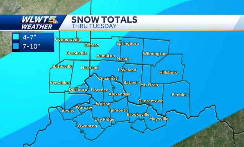
Snowfall amounts anywhere from 7 to 10 inches are looking possible for the Cincinnati metro area, while areas west of I-71 will be a little lower.
We’re still trying to track down an exact accumulation, but expect at least 6 inches of snow, with larger accumulations likely.
Travel will become quite difficult, especially Monday evening into Tuesday. Gusty winds are also expected. Highs Monday will be around 20 degrees with lows in the mid teens.
There is increasing confidence that yet another winter storm will impact the area beyond that, around 36 hours later beginning Wednesday into Thursday. Stay tuned.
Source link


