- Fred is the sixth named storm of the 2021 hurricane season.
- The storm is expected to weaken as it nears the Dominican Republic but it could strengthen before approaching Florida.
- But it's too soon to determine where and when it would hit Florida.
The newly formed Tropical Storm Fred was churning toward the Dominican Republic and Haiti on Wednesday, threatening heavy rains and flooding after it drenched the U.S. Virgin Islands and Puerto Rico.
Fred reached tropical storm strength late Tuesday. The storm passed over the U.S. territories, where power outages were reported, and it could cause river flooding and the potential for mudslides.
The storm is expected to weaken over the Dominican Republic, but strengthen again Thursday evening as it eyes Florida, potentially reaching the bottom of the peninsula by the weekend. Conditions later in the week, though, may limit its intensification, the National Weather Service said.
"It is too soon to determine the exact timing, location and magnitude of any potential impacts" in Florida, the Weather Service said.
Hurricane season is upon us during a pandemic.Here's what you need to protect yourself.
Fred is the sixth named storm of the 2021 hurricane season and first named storm in August, breaking a month-long lull after Hurricane Elsa formed July 9.
Where is Tropical Storm Fred?
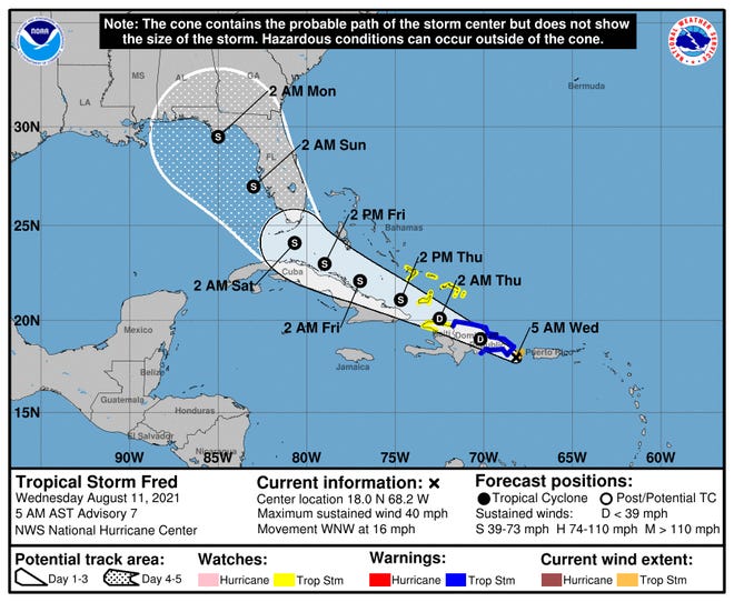
Fred was spinning about 25 miles south-southeast of Santo Domingo in the Dominican Republic as of 11 a.m. EDT. It was heading west-northwest at 16 miles per hour.

What do the spaghetti models forecast for Tropical Storm Fred?
The National Weather Service said Fred is expected to slow down over the next few days.
Most models agreed Fred would head over Santo Domingo and the northern part of Haiti before passing along the northern coast of Cuba.
Later in the week, there is greater uncertainty around Fred's path. Most models have it turning north sometime Friday into Saturday and making its way along the western coast of Florida in the Gulf. In some models, it appears it could make around the Florida Keys.
When is Tropical Storm Fred expected to make landfall?
Fred should make landfall in the Dominican Republic on Wednesday. If and where it could make landfall in the continental United States remains uncertain.
Irreversible changes, warmer temperatures sooner:5 alarming findings from the UN climate change report
How strong is Tropical Storm Fred?
Maximum sustained winds were up to 45 miles per hour on Wednesday.
It could bring isolated patches of rain up to 8 inches in parts of the Dominican Republic, causing flash flooding and mudslides, the Weather Service said.
In Haiti, the Turks and Caicos, eastern Bahamas and eastern Cuba, rainfall up to 5 inches was possible, the Weather Service said. The western Bahamas could see 3 to 5 inches, with isolated areas up to 8 inches.
In Florida, winds and rain could come as soon as Friday The Weather Service said the Keys and southern Florida could also expect to see 3 to 5 inches of rain with areas up to 8 inches through Monday. That raises the possibility of flash flooding, the Weather Service said.
Track Fred's path
Contributing: Megan Kearney, Naples Daily News; The Associated Press
Source link