


Change is coming Monday to severe thunderstorm warnings and how you receive them. Better communication and increased safety during extreme weather are focus of the new emergency alerts coming to your smart phone starting Monday. "I think it's going to be a relatively rare occurrence where we'll use a destructive tag, but it's kind of like the ace in our back pocket," said Wilmington National Weather Service Office Meteorologist Brandon Peloquin. The change will add a new "tags" to the alerts to better convey the severity and potential impacts from thunderstorm winds and hail, similar to tornado and flash flood warnings.The tags will be categorized in three categories, destructive, considerable and base.The tags and additional messaging are designed to promote immediate action, based on the threats.The new "destructive" storm tag will be rare but send an alert to your phone when a split-second decision could make all the difference.Nights like April 8, 2020, when a Clermont County family got to shelter in the nick of time, before powerful wind knocked a tree into their daughter's bedroom that night. Future storms of similar magnitude will be tagged "Destructive," meaning the severe storm is producing winds of 80 mph, or baseball-sized hail. But that's not all. "The important note with the destructive tag is that will activate wireless emergency alerts. So if there is a destructive tag, people's emergency devices will go off if they're in a severe thunderstorm warning," Peloquin said.Like the Amber Alerts that sometimes light up your phone."I think this change will help communication. It will help awareness when these severe thunderstorm warnings are issued," Peloquin said. This coincides with the already-existing wireless emergency alerts for tornado warnings and certain flash flood warnings."We obtained feedback from core partners such as emergency managers and also the broadcast media and the general public as well," Peloquin said.Severe storms with winds of 70 mph or table tennis ball-sized hail will have a "Considerable" tag with them.The criteria for a baseline or “base” severe thunderstorm warning won't change, and will be for storms with one inch, quarter-sized hail and/or 58 mph thunderstorm winds. But it's only the destructive storms that send the alert to your phone. To learn more, visit www.weather.gov.
Change is coming Monday to severe thunderstorm warnings and how you receive them.
Better communication and increased safety during extreme weather are focus of the new emergency alerts coming to your smart phone starting Monday.
"I think it's going to be a relatively rare occurrence where we'll use a destructive tag, but it's kind of like the ace in our back pocket," said Wilmington National Weather Service Office Meteorologist Brandon Peloquin.
The change will add a new "tags" to the alerts to better convey the severity and potential impacts from thunderstorm winds and hail, similar to tornado and flash flood warnings.
The tags will be categorized in three categories, destructive, considerable and base.
The tags and additional messaging are designed to promote immediate action, based on the threats.
The new "destructive" storm tag will be rare but send an alert to your phone when a split-second decision could make all the difference.
Nights like April 8, 2020, when a Clermont County family got to shelter in the nick of time, before powerful wind knocked a tree into their daughter's bedroom that night.
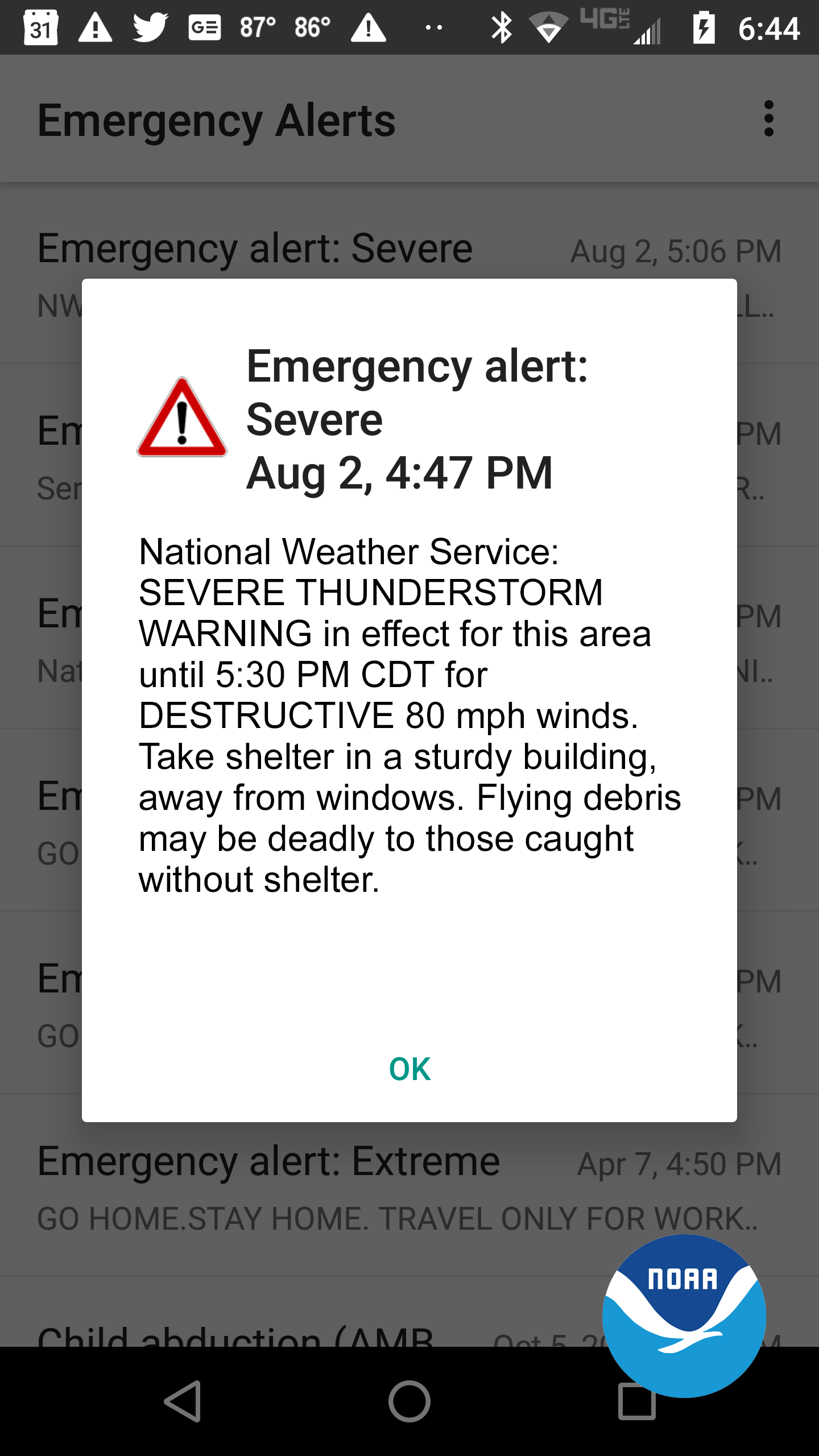
Future storms of similar magnitude will be tagged "Destructive," meaning the severe storm is producing winds of 80 mph, or baseball-sized hail. But that's not all.
"The important note with the destructive tag is that will activate wireless emergency alerts. So if there is a destructive tag, people's emergency devices will go off if they're in a severe thunderstorm warning," Peloquin said.
Like the Amber Alerts that sometimes light up your phone.
"I think this change will help communication. It will help awareness when these severe thunderstorm warnings are issued," Peloquin said.
This coincides with the already-existing wireless emergency alerts for tornado warnings and certain flash flood warnings.
"We obtained feedback from core partners such as emergency managers and also the broadcast media and the general public as well," Peloquin said.
Severe storms with winds of 70 mph or table tennis ball-sized hail will have a "Considerable" tag with them.
The criteria for a baseline or “base” severe thunderstorm warning won't change, and will be for storms with one inch, quarter-sized hail and/or 58 mph thunderstorm winds.
But it's only the destructive storms that send the alert to your phone.
To learn more, visit www.weather.gov.
Source link


