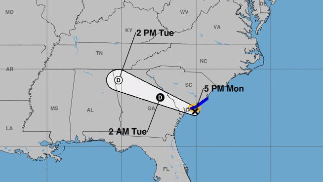
Just hours after Tropical Storm Danny made landfall late Monday near the Georgia-South Carolina border, it weakened to a Tropical Depression, according to the National Hurricane Center.
Heavy rains will continue across Georgia and South Carolina into late Tuesday, when the storm is expected to dissipate.
Tropical storm warnings that were issued for portions of the South Carolina coast as the storm approached were disbanded late Monday.
Earlier, AccuWeather meteorologist Nicole LoBiondo told USA TODAY that "gusty winds are possible with this storm, but the main threat to land will be any persistent downpours where flash flooding is possible, especially in any low-lying and poor drainage areas."
Rough surf and stronger-than-normal rip currents were likely Monday afternoon along the Southeast coast as this system churns up the ocean.
A few inches of rain are possible along the immediate coasts of Georgia and southern South Carolina through Monday night, bringing flooding to normally dry areas. Some areas in South Carolina should expect up to 3 feet of flooding.
As of Monday night, maximum sustained winds were 35 mph. .
A second disturbance – a broad area of low pressure associated with a tropical wave – is producing a small cluster of showers and thunderstorms over the eastern tropical Atlantic Ocean.
In the eastern Pacific Ocean, Hurricane Enrique is forecast to produce heavy rains across southwestern Mexico over the next few days, the hurricane center said.
This season, which officially began June 1, the Atlantic has seen four named storms. This is the fourth time in the modern satellite era there has been a fourth named storm before July 1, according to Weather Channel meteorologist Jim Cantore.
The federal government expects another active Atlantic hurricane season in 2021, and six to 10 hurricanes could form, forecasters said in May.
The season runs through Nov. 30. An average season typically spawns seven hurricanes and peaks in August and September. If predictions hold true, it will be a record sixth consecutive year of above-normal activity.
The National Oceanic and Atmospheric Administration said 13 to 20 named storms will develop. This number includes tropical storms.
How rough will it get? El Niño isn't coming to the rescue: What that means for 2021's hurricane season
In related news:Hurricane 'cone of uncertainty' gets everyone's attention; so will it change again this year?
Another disturbance in the Atlantic
Some slow development of the disturbance over the eastern Atlantic Ocean is possible through the end of the week while the system moves quickly west to west-northwest at about 20 mph, probably reaching the Lesser Antilles late Wednesday or Wednesday night.
"There can be some gradual development with this as it tracks across the Atlantic, and it is possible that this can gain enough organization to become a tropical depression during the first half of the week," AccuWeather senior meteorologist Adam Douty said.
Even if the disturbance fails to organize into a tropical system, gusty showers and thunderstorms are likely in the Lesser Antilles and northwestern Caribbean around the middle of the week, AccuWeather forecasters said.
Tracking the tropics in real time
These graphics, which update automatically, show you activity in the tropics in real time:
Source link


