Tropical Storm Danny forms off South Carolina
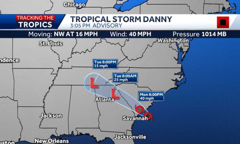
Hey, good afternoon everyone. I. M. W. J. C. L. 22 chief meteorologist Jeremy NElson. With this live weather update just a few moments ago, the National Hurricane Center put out a special statement and with that statement, they have now upgraded our tropical depression forward to tropical storm Danny winds are now at 40 MPH. This is moving off to the northwest at 16 and this is getting very close to the south Carolina coastline. We're expecting a landfall sometime maybe early this evening with that movement to the northwest at 16. This isn't a real slow moving system, so it will be pushing inland as we move from 6 to 8 p.m. And along with that it will be taking some of the showers and thunderstorms with it, but we still have probably a good maybe 2345 hours where we could have these sort of tropical downpour spin through our area. If you're just joining us here on our facebook live session again, thank you so much if you could like and also share this weather information. It's brand new out of the National Hurricane center. We did a live cut in just a couple minutes after the storm was upgraded to a name storm Danny on W. J. C. L. 22. And of course we want to let everyone know here on our facebook live session in a moment. I'll talk about the impact, but certainly anywhere along the way, if you want to stop by leave, any questions or comments that you may have, I'll try to answer those in a timely fashion here. Let's take a look at our storm tracker radar network. Now, if you live well inland, let's start there first because there hasn't been a lot going on today. Just some showers from time to time. A lot of you probably are welcoming in that rain now closer to the coastline. Let's discuss this. This is where a lot of the impacts will be felt when it comes to maybe some of those tropical downpours that could lead to some localized street flooding. This won't be a widespread flood event for our area. Just uh not enough heavy rain out there and this isn't going to be lasting all that long. So what we're looking at now, especially from the savannah River and points north, some of these tropical downpours will be leading to uh Maybe 1" or more of rain in a very short amount of time. If you're in and around Beaufort right now, you just had one of those spin through looks like a couple of lightning strikes with this one. And then offshore we'll talk about this uh a little more detail here in just a second. Let me show you what we're watching for. There are a couple thunderstorms out there that have pretty strong winds associated with those overall. This tropical storm, at least for us here locally is not really a big wind producer. If you've been outside today, there's barely any win for our area. But let's circle a couple of these right there and then this leading edge of this sort of this rain band or this little squall is circulating around the area of low pressure, which I'll show you here in just a second when we zoom out. But this is an area that could be impacting if it continues on this track and brushes by, let's say Hunting Island here could be headed there within the next hour along that leading edge. You may have a wing us very quickly hitting 35 40 MPH, then torrential downpours some lightning with that. And the second area I have circled, we'll see if that brushes by Beaufort County, if it scoots just to the north there and heads towards the Seabrook area And maybe Kiawah Island. Um that's the very latest on the radar now out in the Atlantic right now, some of the winds were a bit stronger earlier, but again, would not be surprised at all at the immediate co sign if there are some wind gusts as these thunderstorms move ashore of about 35 To 40 mph. Here is what I was referring to you when it comes to the greater, wider area of rain and then the main circulation right in this vicinity here, probably going to split between Beaufort and charleston when it does make an official landfall maybe within the next two or three hours. So we're looking at something early this evening. Again, this is a tropical storm maybe in the minds of many. When you think tropical storm, you think, hey, some windy conditions, tons of rainfall. Well, this tropical storm does meet the criteria. The winds are now at 40 mph for us as we've been highlighting for days now. Yeah, there's going to be some tropical downpours over all the rain for most of us will not reach like a flash flood criteria won't create a lot of flooding. So we're going to look at this as a beneficial rain maker and as long as a thunderstorm moves to your area, you're not outside when the lightning moves through. Also, another impact we've seen when we talk about the coastline is an increased threat for rip currents. I have seen some people out swimming at Tybee Island today and especially once these winds start to pick up late afternoon, early evening, definitely in time to exit the water. Here's a live look outside from our harbor town lighthouse camera on Hilton Head Island conditions we're seeing out there right now. We've had some of these rain showers pass through. Looks like a couple of people down on the end of the pier walking around and the flags right now at least down here at the surface. Uh haven't been moving around a whole lot. I know the camera every second or two may freeze up for a little bit uh winds right now, maybe 10 to 15 MPH down on the ground. Flag at the top of the Harbour Town lighthouses moving around. Just a little bit potential impacts as we go from now through this evening. Uh still a pretty high end chance. Some locations will see those tropical downpours and the best chance would be from I 95 points east, If you live west of that area, a lot of times these downpours spin inland and they start to weaken rip current. Risk is still a moderate threat of that. And I'm taking a look over here. The moderate threat for rip currents will continue until at least eight p.m. This evening. That's via the National Weather Service. Any severe storm threat is pretty low and I would say if there is going to be one, it would be tied to those thunderstorms. We highlighted out over the atlantic that could be brushing by parts of Beaufort County. Uh wing us Ellen areas. Now you will not be seen 25 or 30mph winds. That's mainly for areas a little bit closer to the coastline. So that threat is pretty much over the next several hours into this evening. Our impact weather day will continue also through this evening as tropical storm Danny. We're highlighting the downpours, gusty winds and the rip currents. Now this is the fourth named storm of the atlantic hurricane season, all of them either subtropical or tropical storms. So far. We had tropical depression claudette here recently. Give us a wind gust of 50 MPH on Tybee Island. Uh Probably not going to see a wind gust like that this time, but let's see what happens as some of those thunderstorms start to brush by our area. Uh Now we have tropical storm Danny. Elsa is the next system that will be the next name for any system that reaches tropical storm criteria somewhere in hurricane season. And we are watching something out in the atlantic pretty far out right now. Uh I did get a question out here. We always try to breeze through some of these um questions and comments. We have a lot of people out there. Thank you so much for everyone uh supporting us here at W. J. C. L. 22 sharing our weather information. Um Sandra was asking about Tybee Island so I'll try to show you that camera out there right now. Um Let me pop myself up here really quick. Otherwise this may go to black for a moment. Let me see if I can find are Type B camera. Uh Yeah here we go. It is starting to look uh I guess a little more ominous out there right now. The skies are definitely darkening as some of those bands offshore will start to push in. Uh Sometimes they're known as like feeder bands. This isn't really, we're not dealing with hurricane here lower and tropical storm. The wave action today has not been that bad because winds have been a little more out of like a north northwest direction. So it kind of lays some of that near shore water down now. Certainly it could start to get a little more turbulent near shore areas as the thunderstorms push in, the low begins to progress inland and we see winds turn around just a little bit right now. Though anyone that is out on Tybee Island, I'm very happy to see a lot of the sort of the beach patrol on the TVs here. Any lifeguards that are out there, really cautioning people about going into the water due to that rip current risk. So people are just playing around here, uh sort of where the surf begins. Just some of those waves lapping up that's fine, go into your toes, not to your nose, as we like to say here. Uh, and that will be through this evening. So any thunder that you may hear a way in the distance? That means the lightning is close enough to strike you remember earlier this year? Very unfortunate. We did have one fatality on Tybee due to a lightning strike. So please take any thunderstorms that move in any lightning that you may see very seriously out there. Uh That is the latest. Let's take one more second here for anyone that's just hopped on. We have brand new information are tropical depression for is now tropical storm Danny impacts for our area really have not changed. Just some heavier downpours as we go through the late afternoon and into this evening. Wind gusts may pick up a bit at the coastline, but that would probably be directly tied to some thunderstorms that sweep across the area. Tropical storm will move off to the northwest already moving at 16 MPH and then we can quickly as it pushes into north Georgia by early Tuesday morning for us, most of our impacts are right now through the evening overnight quieting down and tomorrow looks like a mainly dry day for a lot of us. Rain chances are back down to 20% and the temperatures will respond and be warmer. All right, that is the very latest again. Thank you so much. If you can like and share this, we'll get this facebook information out to as many people as possible. Coming up here at the top of the hour at four p.m. We'll have a live update on W. J. C. L. 22 then we'll have W. J. C. L. 22 news starting at five p.m. That goes all the way through 6 30 world news tonight is on which we'll be covering this any other happenings across the country. And then we'll be back for W. J. C. L. 22 news at seven. We'll try to do another facebook live this evening. Kind of give you an update if the winds have picked up the coastline. Also, please, please, if you can safely take any photos, videos, share them with us here at W. J. C L. 22. We love to feature your photos, your information during our newscast. Alright, that is the very latest. I'm chief meteorologist Jeremy nelson. I'll see you soon on W J. C L. 22 News.
Tropical Storm Danny forms off South Carolina
Tropical Storm Danny formed Monday afternoon off South Carolina's coast, and forecasters said the storm is expected to race inland over the U.S. Southeast while dumping several inches of rain in some spots.The fourth named storm of the 2021 Atlantic hurricane season formed close to South Carolina's coast and had top sustained winds of 40 mph with higher guests.Tropical storm force winds were already being felt in South Carolina on Monday afternoon. A weather station at Folly Beach — just outside Charleston — recorded a wind gust of 41 mph, according to the National Hurricane Center in Miami.At 3 p.m., the storm was about 45 miles southeast of Charleston, the hurricane center said.The storm was headed to the west-northwest at 16 mph and was expected to dump several inches of rain on some parts of South Carolina and Georgia during its trek inland.Danny emerged from a tropical depression off the coast, and forecasters said rapid weakening is expected after landfall.A tropical storm warning was posted earlier Monday for a swath of the Southeast coast from Edisto Beach to South Santee River, South Carolina.The storm could produce between 1 and 3 inches of rain with higher amounts in some coastal areas.In Savannah, Georgia, all systems were go for Tuesday night’s Savannah Bananas home baseball game as organizers eyed the storm. Officials for the collegiate summer league team planned to cover the field with tarp on Monday in preparation for the game."For us, being on the coast and being in Savannah, we get some nasty pop-up storms that can dump an inch of rain in just a few hours," Bananas President Jared Orton said Monday. "This one doesn't look like much more than just a nice, passing day of rain. I think we're good to go as long as the sun comes out tomorrow and it should be a beautiful night in Savannah, I would think."
Tropical Storm Danny formed Monday afternoon off South Carolina's coast, and forecasters said the storm is expected to race inland over the U.S. Southeast while dumping several inches of rain in some spots.
The fourth named storm of the 2021 Atlantic hurricane season formed close to South Carolina's coast and had top sustained winds of 40 mph with higher guests.
Tropical storm force winds were already being felt in South Carolina on Monday afternoon. A weather station at Folly Beach — just outside Charleston — recorded a wind gust of 41 mph, according to the National Hurricane Center in Miami.
At 3 p.m., the storm was about 45 miles southeast of Charleston, the hurricane center said.
The storm was headed to the west-northwest at 16 mph and was expected to dump several inches of rain on some parts of South Carolina and Georgia during its trek inland.
Danny emerged from a tropical depression off the coast, and forecasters said rapid weakening is expected after landfall.
A tropical storm warning was posted earlier Monday for a swath of the Southeast coast from Edisto Beach to South Santee River, South Carolina.
The storm could produce between 1 and 3 inches of rain with higher amounts in some coastal areas.
In Savannah, Georgia, all systems were go for Tuesday night’s Savannah Bananas home baseball game as organizers eyed the storm. Officials for the collegiate summer league team planned to cover the field with tarp on Monday in preparation for the game.
"For us, being on the coast and being in Savannah, we get some nasty pop-up storms that can dump an inch of rain in just a few hours," Bananas President Jared Orton said Monday. "This one doesn't look like much more than just a nice, passing day of rain. I think we're good to go as long as the sun comes out tomorrow and it should be a beautiful night in Savannah, I would think."
Source link


