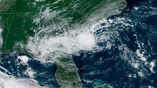
A newly formed tropical depression could make landfall later Monday near the Georgia-South Carolina border, according to the National Hurricane Center.
Heavy rainfall and strong gusty winds with dangerous rip currents are forecast for southeast Georgia. Some showers could arrive throughout the day Monday ahead of the depression's center.
"Gusty winds are possible with this storm, but the main threat to land will be any persistent downpours where flash flooding is possible, especially in any low-lying and poor drainage areas," AccuWeather meteorologist Nicole LoBiondo said.
Rough surf and stronger-than-normal rip currents are likely along the Southeast coast as this system churns up the ocean.
If the depression's wind speed reaches 39 mph this afternoon or evening, it would be named Tropical Storm Danny. Ahead of this, a tropical storm warning has been issued for a portion of the South Carolina coast.
If it becomes Danny, it will be the fourth time in the modern satellite era there has been a fourth named storm before July 1, according to Weather Channel meteorologist Jim Cantore.
Regardless of development, a few inches of rain are possible along the immediate coasts of Georgia and southern South Carolina through Monday night.
Meanwhile, a second disturbance is producing a small cluster of showers and thunderstorms over the eastern tropical Atlantic Ocean. And in the eastern Pacific Ocean, Hurricane Enrique is forecast to produce heavy rains across southwestern Mexico over the next few days, the hurricane center said.
So far this season, which officially began June 1, the Atlantic has seen three named storms.
The federal government expects another active Atlantic hurricane season in 2021, with six to 10 hurricanes forming, forecasters said in May.
The season runs through Nov. 30. An average season typically spawns seven hurricanes and peaks in August and September. If predictions hold true, it will be a record sixth consecutive year of above-normal activity.
Overall, the National Oceanic and Atmospheric Administration said 13 to 20 named storms will develop. This number includes tropical storms.
How rough will it get? El Niño isn't coming to the rescue: What that means for 2021's hurricane season
In related news:Hurricane 'cone of uncertainty' gets everyone's attention; so will it change again this year?
Another disturbance in the Atlantic
Meanwhile, a second disturbance – a broad area of low pressure associated with a tropical wave – is producing a small cluster of showers and thunderstorms over the eastern tropical Atlantic Ocean. It has a 40% chance of forming over the next 28 hours.
Some slow development is possible through the end of the week while this system moves quickly westward to west-northwest at about 20 mph, likely reaching the Lesser Antilles late Wednesday or Wednesday night.
"There can be some gradual development with this as it tracks across the Atlantic and it is possible that this can gain enough organization to become a tropical depression during the first half of the week," AccuWeather senior meteorologist Adam Douty said.
Even if this feature fails to organize into a tropical system, gusty showers and thunderstorms are still likely in the Lesser Antilles and northwestern Caribbean around the middle of the week, said AccuWeather forecasters.
Tracking the tropics in real time
These graphics, which update automatically, show you activity in the tropics in real time:
Source link


