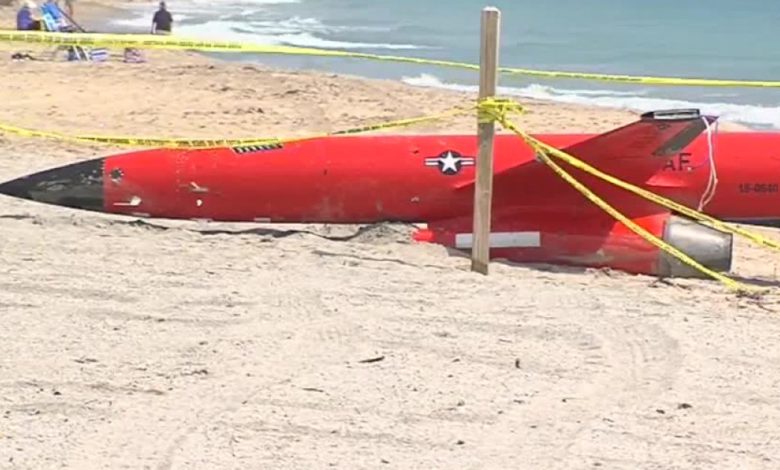
- Parts of Kentucky, West Virginia, Maryland, Virginia, North Carolina and Tennessee will take the first hit Thursday evening.
- The storm could whip up strong winds, pull in more moisture and drive higher snow totals as it heads toward New England.
- More than 100,000 Virginia homes and businesses remained without power Thursday from Monday's storm.
A swath of the East Coast was bracing Thursday for the second major winter storm in five days while blinding snow, high winds and below-zero temperatures rolled across much of the nation's northern tier.
AccuWeather senior meteorologist Joe Lundberg said a storm targeting much of the East should develop into the first bomb cyclone of 2022. A bomb cyclone is defined as a storm whose central pressure plummets 24 millibars in 24 hours. The storm could whip up strong winds, pull in more moisture and drive higher snow totals as it heads toward New England, Lundberg said.
In the East, New York state was already being blasted Thursday by lake-effect snow. Buffalo had already picked up over 13 inches of snow by noon, the National Weather Service said.
"Heavy snow at the Buffalo airport this morning has already established a record for the date," the National Weather Service tweeted Thursday.
In the South, Nashville was also seeing snow Thursday: "Snow has spread across much of Middle Tennessee including Nashville Metro, and travel is deteriorating quickly," the National Weather Service in Nashville tweeted. "1-2 inches per hour could fall at times."
Thursday was the snowiest day in Nashville since Jan. 22, 2016, when 8 inches of snow fell in one day, according to AccuWeather. As of noon Thursday, the airport was up to 4 inches since midnight, AccuWeather said.
Authorities in Tennessee urged people to travel only when necessary. Metro Nashville Police reported accidents and other driving woes that snarled and slowed several roads. Police reported dozens of wrecks on the roads by early afternoon.
Parts of West Virginia, Maryland, Virginia and North Carolina were awaiting the storm, which was due to roll in Thursday afternoon and evening.
In and around Washington, D.C., where more than a foot of snow fell in some places Monday, up to 6 inches more snow was forecast Thursday night into Friday.
WHAT IS A BOMB CYCLONE?:The weather phenomenon is basically a winter hurricane
In Virginia, crews had worked through Tuesday to free up a roughly 50-mile traffic jam in I-95 that trapped scores of drivers in their cars for more than 24 hours. More than 100,000 Virginia homes and businesses remained without power Thursday from Monday's storm.
"These back-to-back storms will generate landmark winter weather that requires extra flexibility, particularly as many continue to deal with power outages," said Gov. Ralph Northam, who declared a state of emergency.
'AN OUTRAGE': Why drivers were left stranded overnight, some for 24 hours, on I-95 in Virginia
Up to a foot of snow could sweep across parts of Maine, Connecticut, Rhode Island and Massachusetts, if the storm strengthens fast enough, AccuWeather said. Boston was expecting up to 8 inches.
"This will be a disruptive storm, and since cold air will be preceding the storm, snow will accumulate on roads as soon as it starts,” AccuWeather meteorologist Bernie Rayno said.
ICE CAUSES DEADLY TRAFFIC ISSUES: Virginia's Gov. Northam declares state of emergency
Lake-effect snow bands were already slamming Buffalo and surrounding areas of western New York on Thursday, producing snowfall rates of 1 to 2 inches per hour. Gusty winds up to 25 mph were also creating limited visibility and dangerous travel conditions along stretches of Interstate 90.
The news wasn't all bad, however: The storm presented a boon to the ski industry in West Virginia, where up to 8 inches of snow was forecast. Three of the state’s four major downhill ski resorts had suspended on-slope operations earlier this week because of warmer conditions. Now the activity was picking back up.
“West Virginia can’t wait to welcome travelers to our snow-capped mountains this winter,” said Chelsea Ruby, secretary of the state’s Department of Tourism.

Elsewhere, in the Upper Midwest, parts of Michigan were buried under a foot of snow, with more expected into Friday. Minnesota and Wisconsin were expecting less snow, but wind chills of minus 25 to minus 35 will continue into Friday morning across much of the state, the weather service said.
And a powerful storm was pounding parts of Colorado on Thursday with what could reach 16 inches of snow, the National Weather Service said. In some areas, winds were gusting to 55 mph.
Contributing: The Associated Press
Source link


