Heating up: It's going to feel like 100 degrees Thursday as daily rain threat continues

Updated: 6:45 AM EDT Aug 12, 2021
DAILY. THAT’S BIG. YES A LOT. THAT’S 100 PLANES. YES GONNA BNGRI IN A LOT OF MONEY TO OUR ECONOMY, WHICH IS GREAT NEWS TO SEE AND MAYBE EVEN BETTER FOR FOLKS GETTING PACKAGES DROPPING THEIR DOOR. HEY, I I’M THE QUEENF O LAST MINUTE SHOPPING. SO THAT MIGHT NOT BE A TERRIBLE. THINK IT’LL HPEL RANDY IF THOSE DELIVERY FOLKS ARE GONNA BE OUT TODAY, PLEASE, YOU KNOW, KEEP THEM IN MIND. I KNOW SOMETIMES PEOPLE PUT LIKE COOLERS OF WATER OR SOMETHING OUT FOR THEM. THIS WOULD BE A GREAT DAY FOR EVERYONE THAT A LOT, YOU KNOW EARLY ON IN THE PANDEMIC THAT THE TREATS IN THE WATER AND TODAY WOULD BE A NICE DAY FOR THAT GESTURE BECAUSE WE’RE TALKING ABOUT TEMPERATURES. THAT’LL BE IN THE LOW 90S,UT B IT’S GONNA FEEL LIKE A HUNDRED OR MORE AS THEY WALK BETWEEN HOUSE TO HOUSE TO HOUSE THIS AFTERNOON. YEAH, LET’S TAKE A LOOK AT WHAT TO EXPECT FOR THE NEXT COUPLE OF DAYS AND ON INTO THE WEEKEND TODAY. THE HEAT IS THE HEADLINE THE COM. OF HTEA AND HUMIDITY IT’S BEEN BUILDING FOR DAYS AND TODAY IT WILL FLEE LIKE 100 DEGREES BY NOON. THAT’S WHY THERE IS A HEATED ADVISORY GOING IONT EFFECT AT NOON. AND WHILE THERE COULD BE A POP-UP DOWNPOUR COURTESY OF ALL THIS HEAT HUMIDITY IN A FRONT SITTING IN NORTHERN, OHIO. IN GENERAL, IT’S ALL ABOUT THE HEAT TODAY THE BETTER CHANCES FOR STOS CRMOME IN FRIDAY AS THAT FRONT SINK SOUTH THAT COULD ALSO BRING US OUR BEST CHANCE THIS WEEK FOR SOME STRONGER STORMS. MAYBE SOME GUSTY WINDS ASHE T FRONT ITSELF SLIDES THROUGH TOMORROW EVENING. BRING ON THE WEEKEND THOHUG ONCE WE GET THERE, THAT FRONT WILL HAVE DONE ITS JOB COOLER MORE COMFORTABL AEIR AND IT WILL BE DRY THE LAST LITTLE BIT OF RAIN OUT OF HERE BY ABOUT 8 AM ON SATURDAY MORNING. SO HERE’S THE HEAT ADVISORY. IT’S FOR EVERYBODY NO MATRTE WHERE YOU ARE THE POTENTIALS THERE FOR IT TO FEEL LIKE 100 TO 105 IN THE SHADE. AND RIGHT NOW IT’S 77 BUT IT ALREADY FEELS LIKE 79 IN THE SUN ISN’T EVEN UP YET THE DEW POINT CURRENTLY 70 THAT GOING TO CLIMB TO ABOUT 74 DEGREES. THAT’S WHERE IT’S BEEN THE LAST COUPLEF OAY DS AND THAT’S HOW WE GET THOSE HEAT INDEXED VALUES THAT GO OVER 100. SO BY NUME, WE’RE 88 FEELING KELI THE UPPER 90S MID-AFTERNOON 92.93 FEELING LIKE 102 103. AND AGAIN, THESE ARE ALLN I THE SHADE IF YOU’RE OUT IN THE DIRECT SUNLIGHT YOU CAN ADD AT LEAST 10 DEGREES TO THAT FEELS LIKE TEMPERATURE. SO THERE’S THE LINE TO THE NORTH. I WAS REFERENCING THIS ALSO BROUGHT SEVERE WEATHER IN THROUGH MILWAUKEE AND PORTIONS OFROUGH MILWAUKEE AND PORTIONS WISCONSIN YESTERDAY AFTERNOON AND EVENING THIS MORNING. AND LIGHTING UP THE SKY IS JTUS OUTSIDE OF CHICAGO. SO WITH THIS FRONT IN OUR VICINITY THE HEAT AND HUMIDITY THAT COU BLDE ENOUGH TO TRIGGER SOME DOWNPOURS LATER IN THE DAY AS WE TAKE A LOOK AT THE FUTURECAST COUPLE OF CLOUDS. HERE’S THE SUN COMES UP A VERY STEAMY OUTLOOK AT LUNCHTIME AND THROUGH THE AFTERNOON FUTURECAST BRINGING AT LEAST THE POTENTIAL FOR SOME POP-UP DOWNPOURS MID-AFTERNOON OR EARLY EVENING, BUT IT’S GOING TO BE THAT FRONT THAT IS MAKING ITS WAY IN OUR DIRECTION THAT BRINGS US BETTER CHANCES FOR RNAI ON FRIDAY IN THE MORNING. I THINK WE COULD BE DEALING WITH THE CLUSTER OF TERMS AND THEN THAT SEVERE WEATHER THREAT POSSIBLE SECOND HALF OF THE DAY FRIDAY. SO TODAY A WEATHER IMPACT DAY. MAINLY FOR THE HEAT AND HUMIDITY FRIDAY AN IMPACT DAY BECAUSE OF THOSE STORMS AND THEN BY THE TIME WE GET INTO THE WEEKEND SATURDAY EARLY IN THE MORNING THAT RAIN IS OUT OF HERE BY ABOUT 8 AM TURNING LESS HUMID THROUGH THE AFTERNOON. IT’LL BE NICE AND COMFORTABLE NEXT WEEK. WE’LL KEEP OURYE E ON WHAT IS CURRENTLY TROPICAL DEPRESSION FRED THAT MAY IMPTAC THE BENGALS SCRIMMAGE THIS WEEKEND OR PRESEASON GAME. WE’LL HAVE TO WATCH THAT BRING SOME RAIN IN THROUGH FLORIDA THIS WEEKEND COULD BRING SOME OUR WAY EARLY NEXT WEEK
Heating up: It's going to feel like 100 degrees Thursday as daily rain threat continues
Updated: 6:45 AM EDT Aug 12, 2021
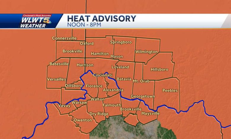
The heat and rain chances continue Thursday making it feel like 100 degrees.A Heat Advisory goes into effect at noon with heat indices ranging from 100 to 104 degrees during the afternoon. Keep pets inside, check on neighbors and limit your time outside. Clusters of downpours and storms will be possible again during the afternoon but the big story will be the heat with highs near 93 degrees.A cool front ushers in storms again Friday, some of which could be strong. This front brings relief in the humidity and heat by the weekend.Sunshine returns with highs in the low to mid 80s and lows near 60 degrees for a fantastic feeling weekend.
The heat and rain chances continue Thursday making it feel like 100 degrees.
A Heat Advisory goes into effect at noon with heat indices ranging from 100 to 104 degrees during the afternoon.
Keep pets inside, check on neighbors and limit your time outside. Clusters of downpours and storms will be possible again during the afternoon but the big story will be the heat with highs near 93 degrees.
A cool front ushers in storms again Friday, some of which could be strong. This front brings relief in the humidity and heat by the weekend.
Sunshine returns with highs in the low to mid 80s and lows near 60 degrees for a fantastic feeling weekend.
Source link